You are here: Home > Network List > AV - Alaska Volcano Observatory Stations List
> Station AMKA Regional Station, Amchitka Island, Alaska > Earthquake Result Viewer
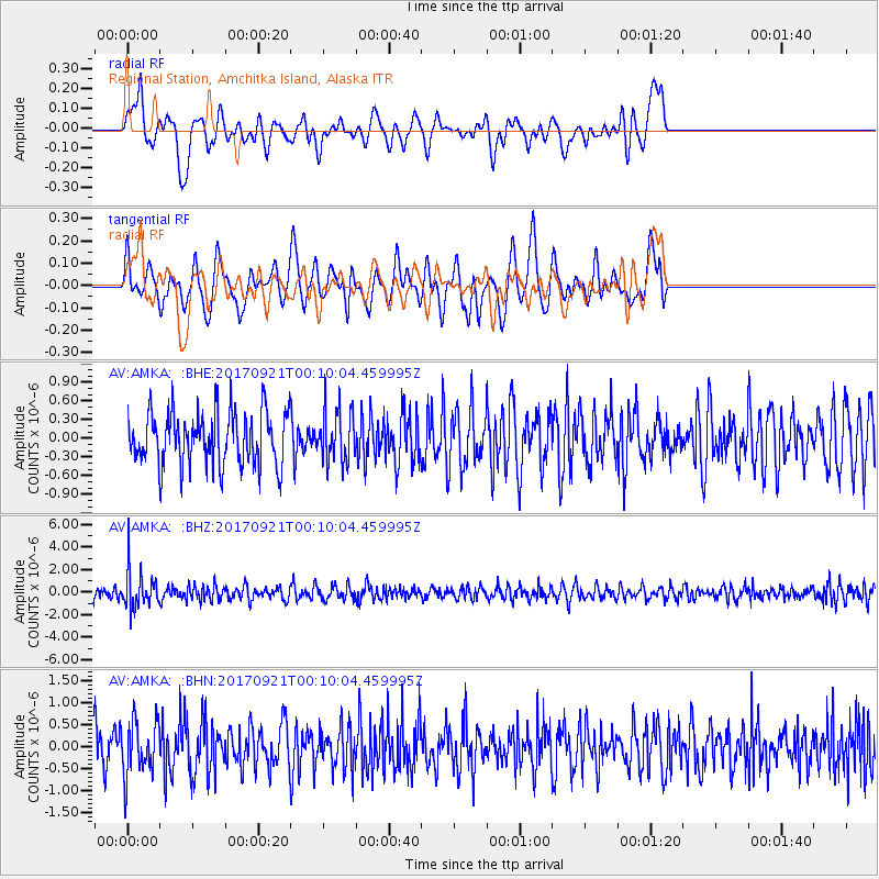
AMKA Regional Station, Amchitka Island, Alaska - Earthquake Result Viewer
*The percent match for this event was below the threshold and hence no stack was calculated.
| Earthquake location: |
Java, Indonesia |
| Earthquake latitude/longitude: |
-6.1/113.0 |
| Earthquake time(UTC): |
2017/09/20 (263) 23:59:24 GMT |
| Earthquake Depth: |
589 km |
| Earthquake Magnitude: |
5.7 Mww |
| Earthquake Catalog/Contributor: |
NEIC PDE/us |
|
| Network: |
AV Alaska Volcano Observatory |
| Station: |
AMKA Regional Station, Amchitka Island, Alaska |
| Lat/Lon: |
51.38 N/179.30 E |
| Elevation: |
116 m |
|
| Distance: |
80.3 deg |
| Az: |
35.599 deg |
| Baz: |
247.451 deg |
| Ray Param: |
$rayparam |
*The percent match for this event was below the threshold and hence was not used in the summary stack. |
|
| Radial Match: |
49.645584 % |
| Radial Bump: |
400 |
| Transverse Match: |
62.30279 % |
| Transverse Bump: |
400 |
| SOD ConfigId: |
13570011 |
| Insert Time: |
2019-04-28 20:36:18.784 +0000 |
| GWidth: |
2.5 |
| Max Bumps: |
400 |
| Tol: |
0.001 |
|
Signal To Noise
| Channel | StoN | STA | LTA |
| AV:AMKA: :BHZ:20170921T00:10:04.459995Z | 2.9106479 | 1.6606153E-6 | 5.705312E-7 |
| AV:AMKA: :BHN:20170921T00:10:04.459995Z | 1.1343977 | 6.105082E-7 | 5.3817826E-7 |
| AV:AMKA: :BHE:20170921T00:10:04.459995Z | 0.9613393 | 4.1215458E-7 | 4.2872958E-7 |
| Arrivals |
| Ps | |
| PpPs | |
| PsPs/PpSs | |


