You are here: Home > Network List > TA - USArray Transportable Network (new EarthScope stations) Stations List
> Station I15A Monteview, ID, USA > Earthquake Result Viewer
I15A Monteview, ID, USA - Earthquake Result Viewer
*The percent match for this event was below the threshold and hence no stack was calculated.
| Earthquake location: |
Samoa Islands Region |
| Earthquake latitude/longitude: |
-17.0/-172.1 |
| Earthquake time(UTC): |
2009/01/28 (028) 12:39:42 GMT |
| Earthquake Depth: |
10 km |
| Earthquake Magnitude: |
5.6 MB, 5.3 MS, 5.5 MW |
| Earthquake Catalog/Contributor: |
WHDF/NEIC |
|
| Network: |
TA USArray Transportable Network (new EarthScope stations) |
| Station: |
I15A Monteview, ID, USA |
| Lat/Lon: |
44.00 N/112.49 W |
| Elevation: |
1470 m |
|
| Distance: |
81.4 deg |
| Az: |
39.002 deg |
| Baz: |
236.57 deg |
| Ray Param: |
$rayparam |
*The percent match for this event was below the threshold and hence was not used in the summary stack. |
|
| Radial Match: |
67.752464 % |
| Radial Bump: |
381 |
| Transverse Match: |
68.20127 % |
| Transverse Bump: |
400 |
| SOD ConfigId: |
2658 |
| Insert Time: |
2010-03-06 04:08:30.815 +0000 |
| GWidth: |
2.5 |
| Max Bumps: |
400 |
| Tol: |
0.001 |
|
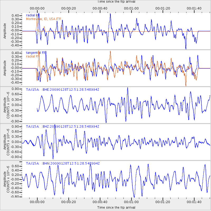
Signal To Noise
| Channel | StoN | STA | LTA |
| TA:I15A: :BHZ:20090128T12:51:28.548994Z | 3.5902545 | 3.5302546E-7 | 9.8328805E-8 |
| TA:I15A: :BHN:20090128T12:51:28.548994Z | 1.2305604 | 2.5123077E-7 | 2.0415965E-7 |
| TA:I15A: :BHE:20090128T12:51:28.548994Z | 0.7403896 | 2.1720828E-7 | 2.9337025E-7 |
| Arrivals |
| Ps | |
| PpPs | |
| PsPs/PpSs | |


