You are here: Home > Network List > TJ - Tajikistan National Seismic Network Stations List
> Station GARM Garm, Tajikistan > Earthquake Result Viewer
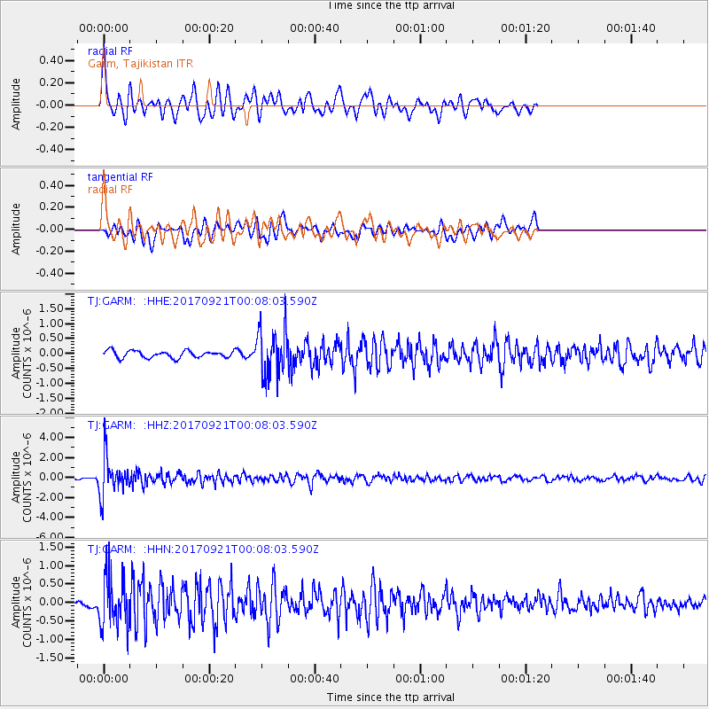
GARM Garm, Tajikistan - Earthquake Result Viewer
*The percent match for this event was below the threshold and hence no stack was calculated.
| Earthquake location: |
Java, Indonesia |
| Earthquake latitude/longitude: |
-6.1/113.0 |
| Earthquake time(UTC): |
2017/09/20 (263) 23:59:24 GMT |
| Earthquake Depth: |
589 km |
| Earthquake Magnitude: |
5.7 Mww |
| Earthquake Catalog/Contributor: |
NEIC PDE/us |
|
| Network: |
TJ Tajikistan National Seismic Network |
| Station: |
GARM Garm, Tajikistan |
| Lat/Lon: |
39.00 N/70.32 E |
| Elevation: |
1305 m |
|
| Distance: |
59.8 deg |
| Az: |
322.322 deg |
| Baz: |
128.742 deg |
| Ray Param: |
$rayparam |
*The percent match for this event was below the threshold and hence was not used in the summary stack. |
|
| Radial Match: |
78.737595 % |
| Radial Bump: |
400 |
| Transverse Match: |
68.11022 % |
| Transverse Bump: |
400 |
| SOD ConfigId: |
13570011 |
| Insert Time: |
2019-04-28 20:38:24.695 +0000 |
| GWidth: |
2.5 |
| Max Bumps: |
400 |
| Tol: |
0.001 |
|
Signal To Noise
| Channel | StoN | STA | LTA |
| TJ:GARM: :HHZ:20170921T00:08:03.590Z | 21.239218 | 1.9620581E-6 | 9.2379025E-8 |
| TJ:GARM: :HHN:20170921T00:08:03.590Z | 7.739916 | 6.896651E-7 | 8.910499E-8 |
| TJ:GARM: :HHE:20170921T00:08:03.590Z | 6.76797 | 7.9483834E-7 | 1.1744117E-7 |
| Arrivals |
| Ps | |
| PpPs | |
| PsPs/PpSs | |


