You are here: Home > Network List > AK - Alaska Regional Network Stations List
> Station MDM Murphy Dome > Earthquake Result Viewer
MDM Murphy Dome - Earthquake Result Viewer
| Earthquake location: |
Tonga Islands |
| Earthquake latitude/longitude: |
-15.1/-173.4 |
| Earthquake time(UTC): |
2016/03/08 (068) 05:36:27 GMT |
| Earthquake Depth: |
30 km |
| Earthquake Magnitude: |
5.8 MB |
| Earthquake Catalog/Contributor: |
NEIC PDE/NEIC COMCAT |
|
| Network: |
AK Alaska Regional Network |
| Station: |
MDM Murphy Dome |
| Lat/Lon: |
64.96 N/148.23 W |
| Elevation: |
634 m |
|
| Distance: |
82.1 deg |
| Az: |
10.535 deg |
| Baz: |
204.511 deg |
| Ray Param: |
0.04706694 |
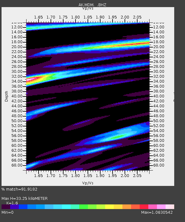
| Estimated Moho Depth: |
33.25 km |
| Estimated Crust Vp/Vs: |
1.60 |
| Assumed Crust Vp: |
6.566 km/s |
| Estimated Crust Vs: |
4.104 km/s |
| Estimated Crust Poisson's Ratio: |
0.18 |
|
| Radial Match: |
91.9182 % |
| Radial Bump: |
353 |
| Transverse Match: |
60.360523 % |
| Transverse Bump: |
400 |
| SOD ConfigId: |
1453031 |
| Insert Time: |
2016-03-22 06:04:16.067 +0000 |
| GWidth: |
2.5 |
| Max Bumps: |
400 |
| Tol: |
0.001 |
|

Signal To Noise
| Channel | StoN | STA | LTA |
| AK:MDM: :BHZ:20160308T05:48:14.228025Z | 7.4396677 | 8.147968E-7 | 1.0952059E-7 |
| AK:MDM: :BHN:20160308T05:48:14.228025Z | 2.430481 | 3.0562126E-7 | 1.2574517E-7 |
| AK:MDM: :BHE:20160308T05:48:14.228025Z | 0.96971154 | 1.573805E-7 | 1.6229619E-7 |
| Arrivals |
| Ps | 3.1 SECOND |
| PpPs | 13 SECOND |
| PsPs/PpSs | 16 SECOND |


