You are here: Home > Network List > AK - Alaska Regional Network Stations List
> Station CUT Chulitna, AK, USA > Earthquake Result Viewer
CUT Chulitna, AK, USA - Earthquake Result Viewer
| Earthquake location: |
Tonga Islands |
| Earthquake latitude/longitude: |
-15.1/-173.4 |
| Earthquake time(UTC): |
2016/03/08 (068) 05:36:27 GMT |
| Earthquake Depth: |
30 km |
| Earthquake Magnitude: |
5.8 MB |
| Earthquake Catalog/Contributor: |
NEIC PDE/NEIC COMCAT |
|
| Network: |
AK Alaska Regional Network |
| Station: |
CUT Chulitna, AK, USA |
| Lat/Lon: |
62.41 N/150.26 W |
| Elevation: |
574 m |
|
| Distance: |
79.4 deg |
| Az: |
10.734 deg |
| Baz: |
202.722 deg |
| Ray Param: |
0.048939113 |
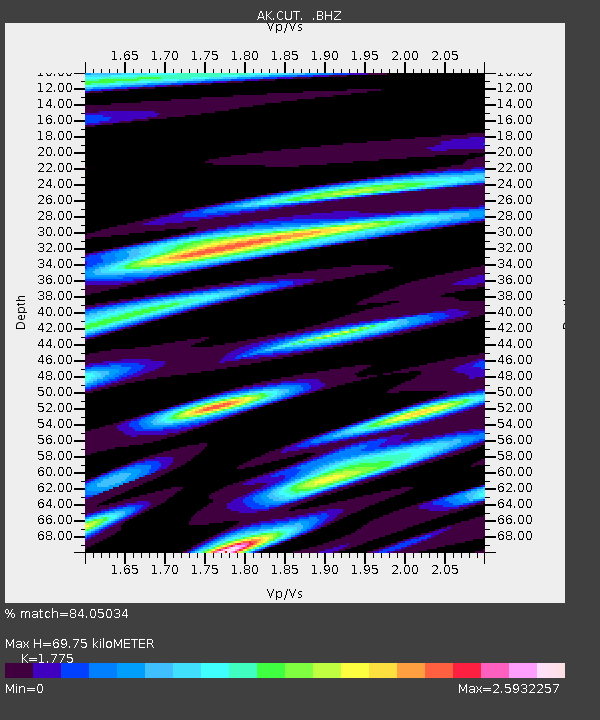
| Estimated Moho Depth: |
69.75 km |
| Estimated Crust Vp/Vs: |
1.77 |
| Assumed Crust Vp: |
6.438 km/s |
| Estimated Crust Vs: |
3.627 km/s |
| Estimated Crust Poisson's Ratio: |
0.27 |
|
| Radial Match: |
84.05034 % |
| Radial Bump: |
400 |
| Transverse Match: |
67.493324 % |
| Transverse Bump: |
400 |
| SOD ConfigId: |
1453031 |
| Insert Time: |
2016-03-22 06:05:50.612 +0000 |
| GWidth: |
2.5 |
| Max Bumps: |
400 |
| Tol: |
0.001 |
|

Signal To Noise
| Channel | StoN | STA | LTA |
| AK:CUT: :BHZ:20160308T05:47:59.799985Z | 4.518716 | 8.8532505E-7 | 1.9592403E-7 |
| AK:CUT: :BHN:20160308T05:47:59.799985Z | 0.8517414 | 3.4614314E-7 | 4.0639466E-7 |
| AK:CUT: :BHE:20160308T05:47:59.799985Z | 1.7872677 | 6.996233E-7 | 3.9144854E-7 |
| Arrivals |
| Ps | 8.6 SECOND |
| PpPs | 29 SECOND |
| PsPs/PpSs | 38 SECOND |


