You are here: Home > Network List > TA - USArray Transportable Network (new EarthScope stations) Stations List
> Station Z20A Nine Sixteen Ranch, Cliff, NM, USA > Earthquake Result Viewer
Z20A Nine Sixteen Ranch, Cliff, NM, USA - Earthquake Result Viewer
| Earthquake location: |
Santa Cruz Islands Region |
| Earthquake latitude/longitude: |
-11.0/164.5 |
| Earthquake time(UTC): |
2008/07/19 (201) 09:27:01 GMT |
| Earthquake Depth: |
11 km |
| Earthquake Magnitude: |
6.1 MB, 6.4 MS, 6.6 MW, 6.6 MW |
| Earthquake Catalog/Contributor: |
WHDF/NEIC |
|
| Network: |
TA USArray Transportable Network (new EarthScope stations) |
| Station: |
Z20A Nine Sixteen Ranch, Cliff, NM, USA |
| Lat/Lon: |
33.11 N/108.59 W |
| Elevation: |
1547 m |
|
| Distance: |
93.4 deg |
| Az: |
57.089 deg |
| Baz: |
259.12 deg |
| Ray Param: |
0.04127 |
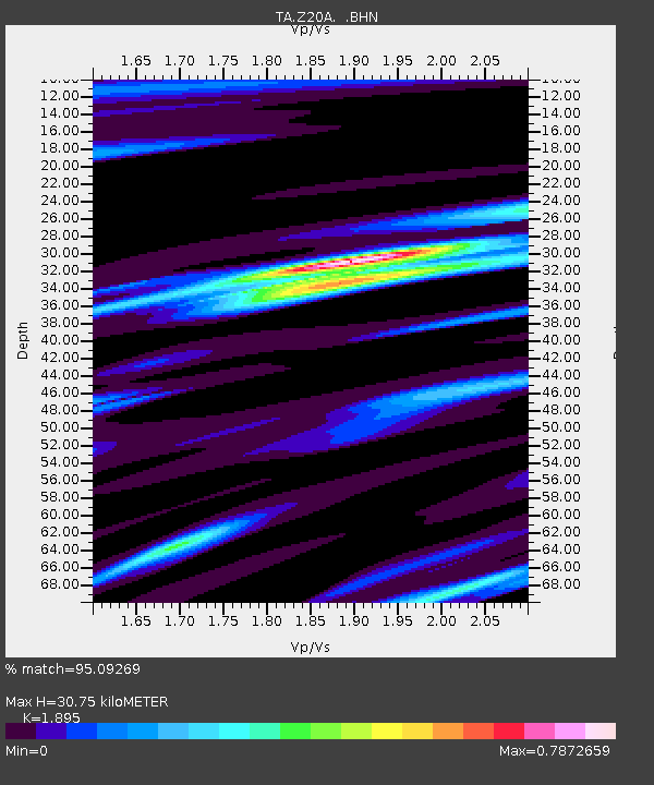
| Estimated Moho Depth: |
30.75 km |
| Estimated Crust Vp/Vs: |
1.89 |
| Assumed Crust Vp: |
6.276 km/s |
| Estimated Crust Vs: |
3.312 km/s |
| Estimated Crust Poisson's Ratio: |
0.31 |
|
| Radial Match: |
95.09269 % |
| Radial Bump: |
337 |
| Transverse Match: |
75.54753 % |
| Transverse Bump: |
367 |
| SOD ConfigId: |
2658 |
| Insert Time: |
2010-03-06 04:10:06.105 +0000 |
| GWidth: |
2.5 |
| Max Bumps: |
400 |
| Tol: |
0.001 |
|
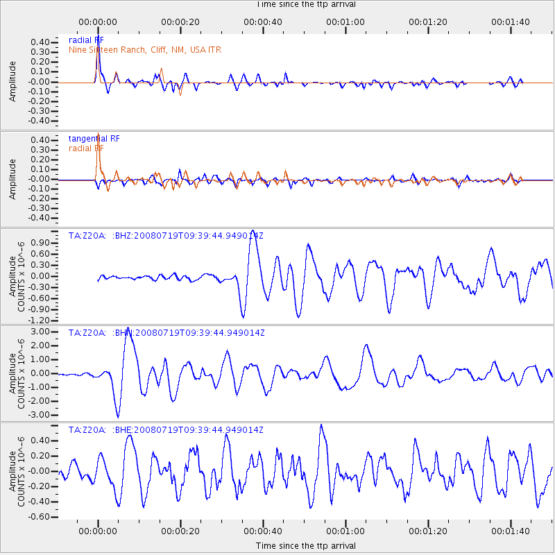
Signal To Noise
| Channel | StoN | STA | LTA |
| TA:Z20A: :BHN:20080719T09:39:44.949014Z | 13.055559 | 1.0897118E-6 | 8.346726E-8 |
| TA:Z20A: :BHE:20080719T09:39:44.949014Z | 2.3552613 | 1.9909318E-7 | 8.453125E-8 |
| TA:Z20A: :BHZ:20080719T09:39:44.949014Z | 5.3159423 | 2.6228193E-7 | 4.9338748E-8 |
| Arrivals |
| Ps | 4.5 SECOND |
| PpPs | 14 SECOND |
| PsPs/PpSs | 18 SECOND |


