You are here: Home > Network List > TA - USArray Transportable Network (new EarthScope stations) Stations List
> Station D23K Nanushuk River, AK USA > Earthquake Result Viewer
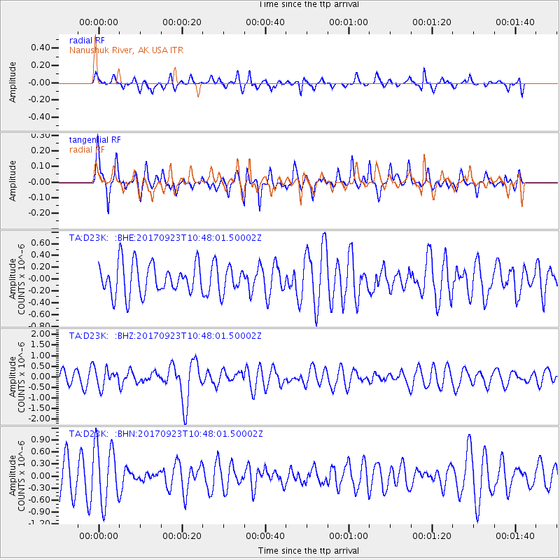
D23K Nanushuk River, AK USA - Earthquake Result Viewer
*The percent match for this event was below the threshold and hence no stack was calculated.
| Earthquake location: |
Near Coast Of Oaxaca, Mexico |
| Earthquake latitude/longitude: |
15.7/-94.2 |
| Earthquake time(UTC): |
2017/09/23 (266) 10:38:08 GMT |
| Earthquake Depth: |
74 km |
| Earthquake Magnitude: |
5.8 Mww |
| Earthquake Catalog/Contributor: |
NEIC PDE/us |
|
| Network: |
TA USArray Transportable Network (new EarthScope stations) |
| Station: |
D23K Nanushuk River, AK USA |
| Lat/Lon: |
68.97 N/150.68 W |
| Elevation: |
406 m |
|
| Distance: |
63.7 deg |
| Az: |
340.379 deg |
| Baz: |
116.38 deg |
| Ray Param: |
$rayparam |
*The percent match for this event was below the threshold and hence was not used in the summary stack. |
|
| Radial Match: |
42.53421 % |
| Radial Bump: |
357 |
| Transverse Match: |
61.75973 % |
| Transverse Bump: |
309 |
| SOD ConfigId: |
13570011 |
| Insert Time: |
2019-04-28 20:52:40.416 +0000 |
| GWidth: |
2.5 |
| Max Bumps: |
400 |
| Tol: |
0.001 |
|
Signal To Noise
| Channel | StoN | STA | LTA |
| TA:D23K: :BHZ:20170923T10:48:01.50002Z | 1.5554482 | 4.0609888E-7 | 2.6108157E-7 |
| TA:D23K: :BHN:20170923T10:48:01.50002Z | 2.1672308 | 7.428109E-7 | 3.4274657E-7 |
| TA:D23K: :BHE:20170923T10:48:01.50002Z | 0.67464644 | 1.7864666E-7 | 2.6480043E-7 |
| Arrivals |
| Ps | |
| PpPs | |
| PsPs/PpSs | |


