You are here: Home > Network List > TA - USArray Transportable Network (new EarthScope stations) Stations List
> Station MDND Maddock, ND, USA > Earthquake Result Viewer
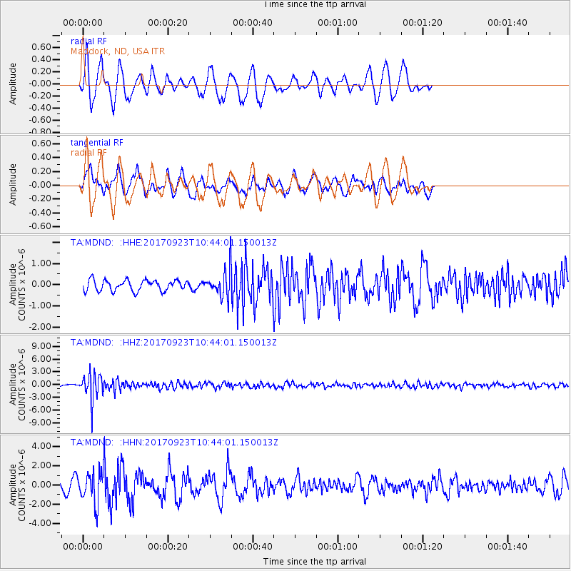
MDND Maddock, ND, USA - Earthquake Result Viewer
*The percent match for this event was below the threshold and hence no stack was calculated.
| Earthquake location: |
Near Coast Of Oaxaca, Mexico |
| Earthquake latitude/longitude: |
15.7/-94.2 |
| Earthquake time(UTC): |
2017/09/23 (266) 10:38:08 GMT |
| Earthquake Depth: |
74 km |
| Earthquake Magnitude: |
5.8 Mww |
| Earthquake Catalog/Contributor: |
NEIC PDE/us |
|
| Network: |
TA USArray Transportable Network (new EarthScope stations) |
| Station: |
MDND Maddock, ND, USA |
| Lat/Lon: |
47.85 N/99.60 W |
| Elevation: |
479 m |
|
| Distance: |
32.4 deg |
| Az: |
353.15 deg |
| Baz: |
170.18 deg |
| Ray Param: |
$rayparam |
*The percent match for this event was below the threshold and hence was not used in the summary stack. |
|
| Radial Match: |
66.83377 % |
| Radial Bump: |
354 |
| Transverse Match: |
62.841133 % |
| Transverse Bump: |
381 |
| SOD ConfigId: |
13570011 |
| Insert Time: |
2019-04-28 20:53:01.373 +0000 |
| GWidth: |
2.5 |
| Max Bumps: |
400 |
| Tol: |
0.001 |
|
Signal To Noise
| Channel | StoN | STA | LTA |
| TA:MDND: :HHZ:20170923T10:44:01.150013Z | 18.575903 | 3.076903E-6 | 1.6563949E-7 |
| TA:MDND: :HHN:20170923T10:44:01.150013Z | 2.3361213 | 1.7177041E-6 | 7.352803E-7 |
| TA:MDND: :HHE:20170923T10:44:01.150013Z | 2.7269657 | 6.8653986E-7 | 2.5175962E-7 |
| Arrivals |
| Ps | |
| PpPs | |
| PsPs/PpSs | |


