You are here: Home > Network List > TA - USArray Transportable Network (new EarthScope stations) Stations List
> Station Z20A Nine Sixteen Ranch, Cliff, NM, USA > Earthquake Result Viewer
Z20A Nine Sixteen Ranch, Cliff, NM, USA - Earthquake Result Viewer
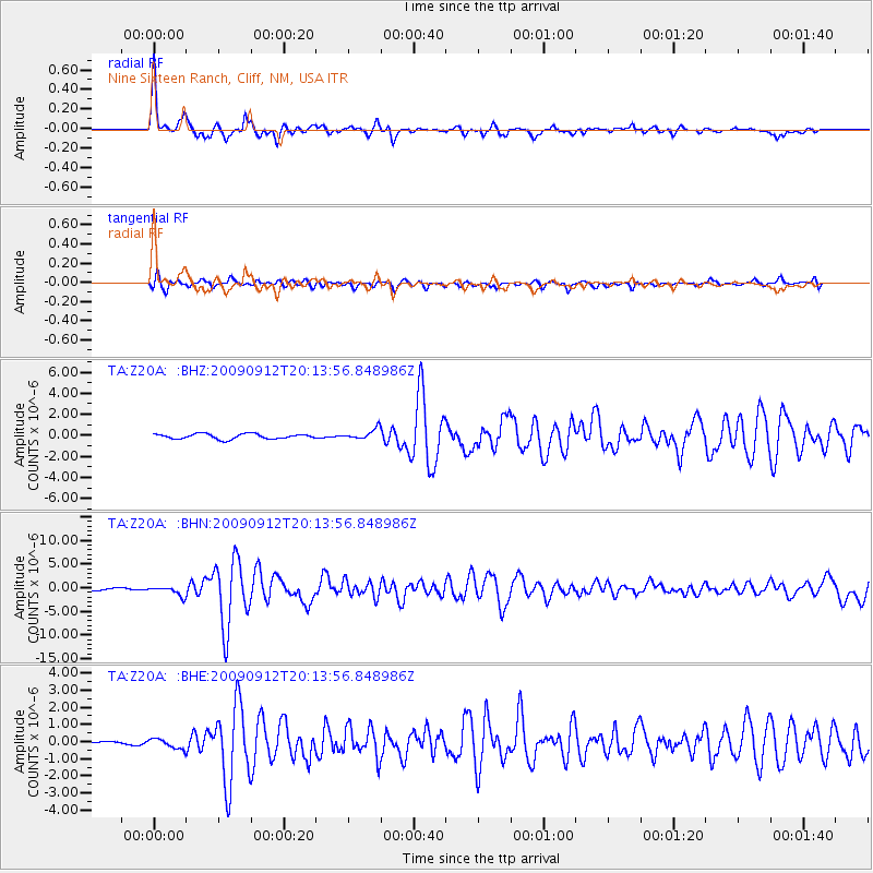
| Earthquake location: |
Near Coast Of Venezuela |
| Earthquake latitude/longitude: |
10.7/-67.9 |
| Earthquake time(UTC): |
2009/09/12 (255) 20:06:24 GMT |
| Earthquake Depth: |
10 km |
| Earthquake Magnitude: |
6.3 MB, 6.4 MS, 6.3 MW, 6.3 MW |
| Earthquake Catalog/Contributor: |
WHDF/NEIC |
|
| Network: |
TA USArray Transportable Network (new EarthScope stations) |
| Station: |
Z20A Nine Sixteen Ranch, Cliff, NM, USA |
| Lat/Lon: |
33.11 N/108.59 W |
| Elevation: |
1547 m |
|
| Distance: |
43.5 deg |
| Az: |
307.315 deg |
| Baz: |
111.353 deg |
| Ray Param: |
0.0725436 |
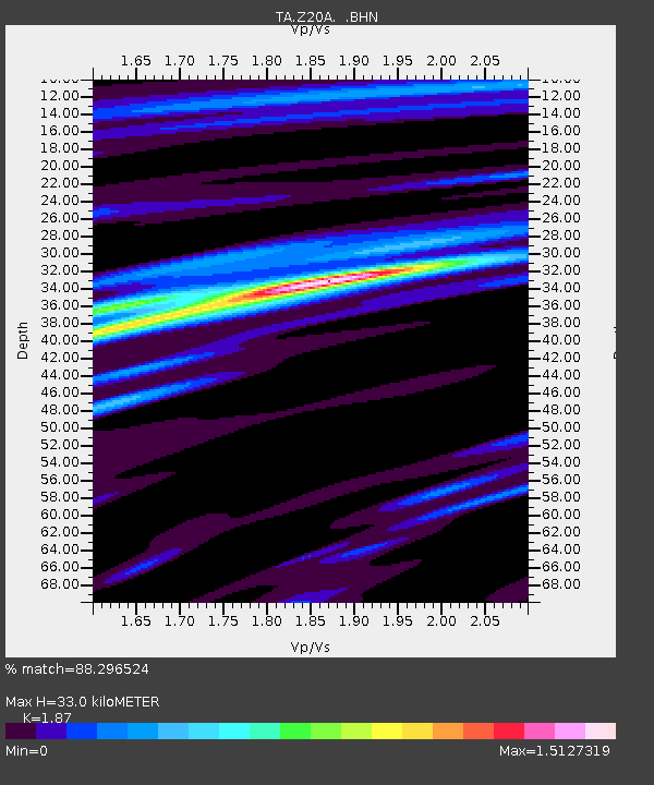
| Estimated Moho Depth: |
33.0 km |
| Estimated Crust Vp/Vs: |
1.87 |
| Assumed Crust Vp: |
6.276 km/s |
| Estimated Crust Vs: |
3.356 km/s |
| Estimated Crust Poisson's Ratio: |
0.30 |
|
| Radial Match: |
88.296524 % |
| Radial Bump: |
344 |
| Transverse Match: |
74.86676 % |
| Transverse Bump: |
400 |
| SOD ConfigId: |
2622 |
| Insert Time: |
2010-03-06 04:10:28.268 +0000 |
| GWidth: |
2.5 |
| Max Bumps: |
400 |
| Tol: |
0.001 |
|
Signal To Noise
| Channel | StoN | STA | LTA |
| TA:Z20A: :BHN:20090912T20:13:56.848986Z | 5.302035 | 9.824164E-7 | 1.8529043E-7 |
| TA:Z20A: :BHE:20090912T20:13:56.848986Z | 3.1283143 | 2.8418526E-7 | 9.084294E-8 |
| TA:Z20A: :BHZ:20090912T20:13:56.848986Z | 2.083341 | 5.049171E-7 | 2.4235933E-7 |
| Arrivals |
| Ps | 4.9 SECOND |
| PpPs | 14 SECOND |
| PsPs/PpSs | 19 SECOND |


