You are here: Home > Network List > TA - USArray Transportable Network (new EarthScope stations) Stations List
> Station Z20A Nine Sixteen Ranch, Cliff, NM, USA > Earthquake Result Viewer
Z20A Nine Sixteen Ranch, Cliff, NM, USA - Earthquake Result Viewer

| Earthquake location: |
Sea Of Okhotsk |
| Earthquake latitude/longitude: |
54.2/154.3 |
| Earthquake time(UTC): |
2008/11/24 (329) 09:02:58 GMT |
| Earthquake Depth: |
492 km |
| Earthquake Magnitude: |
6.5 MB, 7.3 MW, 7.3 MW |
| Earthquake Catalog/Contributor: |
WHDF/NEIC |
|
| Network: |
TA USArray Transportable Network (new EarthScope stations) |
| Station: |
Z20A Nine Sixteen Ranch, Cliff, NM, USA |
| Lat/Lon: |
33.11 N/108.59 W |
| Elevation: |
1547 m |
|
| Distance: |
67.7 deg |
| Az: |
64.167 deg |
| Baz: |
320.945 deg |
| Ray Param: |
0.05509808 |
| Estimated Moho Depth: |
10.75 km |
| Estimated Crust Vp/Vs: |
1.72 |
| Assumed Crust Vp: |
6.276 km/s |
| Estimated Crust Vs: |
3.659 km/s |
| Estimated Crust Poisson's Ratio: |
0.24 |
|
| Radial Match: |
82.173874 % |
| Radial Bump: |
400 |
| Transverse Match: |
65.31629 % |
| Transverse Bump: |
400 |
| SOD ConfigId: |
2658 |
| Insert Time: |
2010-03-06 04:10:43.521 +0000 |
| GWidth: |
2.5 |
| Max Bumps: |
400 |
| Tol: |
0.001 |
|
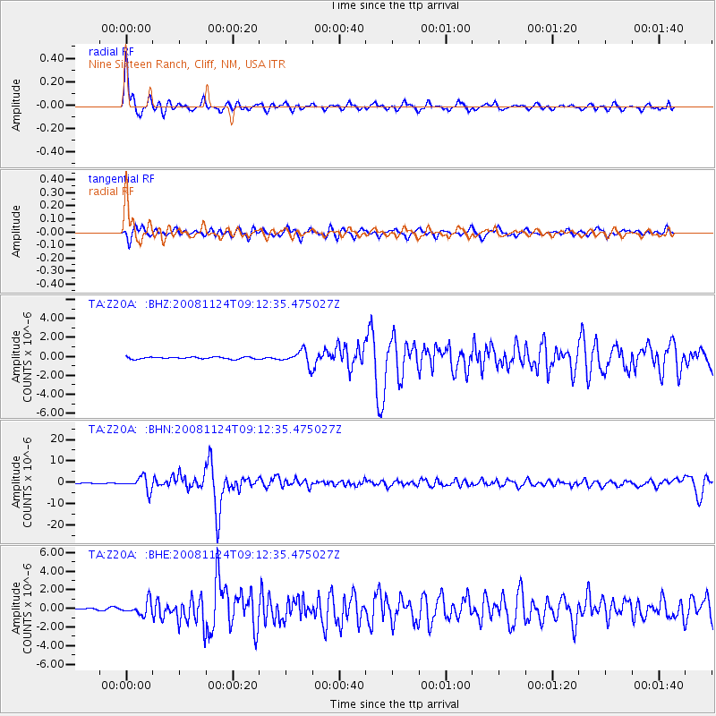
Signal To Noise
| Channel | StoN | STA | LTA |
| TA:Z20A: :BHN:20081124T09:12:35.475027Z | 25.267426 | 3.2354017E-6 | 1.2804635E-7 |
| TA:Z20A: :BHE:20081124T09:12:35.475027Z | 5.854607 | 7.2902225E-7 | 1.2452114E-7 |
| TA:Z20A: :BHZ:20081124T09:12:35.475027Z | 7.57152 | 7.5557256E-7 | 9.97914E-8 |
| Arrivals |
| Ps | 1.3 SECOND |
| PpPs | 4.5 SECOND |
| PsPs/PpSs | 5.8 SECOND |


