You are here: Home > Network List > TA - USArray Transportable Network (new EarthScope stations) Stations List
> Station Z20A Nine Sixteen Ranch, Cliff, NM, USA > Earthquake Result Viewer
Z20A Nine Sixteen Ranch, Cliff, NM, USA - Earthquake Result Viewer
| Earthquake location: |
Kermadec Islands Region |
| Earthquake latitude/longitude: |
-31.2/-176.9 |
| Earthquake time(UTC): |
2008/12/09 (344) 06:23:59 GMT |
| Earthquake Depth: |
18 km |
| Earthquake Magnitude: |
6.2 MB, 6.7 MS, 6.8 MW, 6.7 MW |
| Earthquake Catalog/Contributor: |
WHDF/NEIC |
|
| Network: |
TA USArray Transportable Network (new EarthScope stations) |
| Station: |
Z20A Nine Sixteen Ranch, Cliff, NM, USA |
| Lat/Lon: |
33.11 N/108.59 W |
| Elevation: |
1547 m |
|
| Distance: |
90.9 deg |
| Az: |
51.265 deg |
| Baz: |
232.766 deg |
| Ray Param: |
0.041641667 |
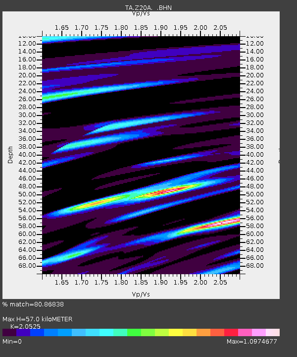
| Estimated Moho Depth: |
57.0 km |
| Estimated Crust Vp/Vs: |
2.05 |
| Assumed Crust Vp: |
6.276 km/s |
| Estimated Crust Vs: |
3.058 km/s |
| Estimated Crust Poisson's Ratio: |
0.34 |
|
| Radial Match: |
80.86838 % |
| Radial Bump: |
347 |
| Transverse Match: |
60.921677 % |
| Transverse Bump: |
373 |
| SOD ConfigId: |
2658 |
| Insert Time: |
2010-03-06 04:10:52.505 +0000 |
| GWidth: |
2.5 |
| Max Bumps: |
400 |
| Tol: |
0.001 |
|

Signal To Noise
| Channel | StoN | STA | LTA |
| TA:Z20A: :BHN:20081209T06:36:30.525024Z | 2.2436762 | 1.2644397E-6 | 5.6355714E-7 |
| TA:Z20A: :BHE:20081209T06:36:30.525024Z | 1.0018994 | 4.79999E-7 | 4.7908907E-7 |
| TA:Z20A: :BHZ:20081209T06:36:30.525024Z | 1.9663568 | 8.584983E-7 | 4.3659335E-7 |
| Arrivals |
| Ps | 9.7 SECOND |
| PpPs | 27 SECOND |
| PsPs/PpSs | 37 SECOND |


