You are here: Home > Network List > TA - USArray Transportable Network (new EarthScope stations) Stations List
> Station Z20A Nine Sixteen Ranch, Cliff, NM, USA > Earthquake Result Viewer
Z20A Nine Sixteen Ranch, Cliff, NM, USA - Earthquake Result Viewer
| Earthquake location: |
Kodiak Island Region, Alaska |
| Earthquake latitude/longitude: |
56.5/-152.7 |
| Earthquake time(UTC): |
2009/03/30 (089) 07:13:07 GMT |
| Earthquake Depth: |
21 km |
| Earthquake Magnitude: |
5.9 MB, 5.9 MS, 5.9 MW, 5.9 MW |
| Earthquake Catalog/Contributor: |
WHDF/NEIC |
|
| Network: |
TA USArray Transportable Network (new EarthScope stations) |
| Station: |
Z20A Nine Sixteen Ranch, Cliff, NM, USA |
| Lat/Lon: |
33.11 N/108.59 W |
| Elevation: |
1547 m |
|
| Distance: |
38.2 deg |
| Az: |
108.909 deg |
| Baz: |
321.369 deg |
| Ray Param: |
0.075690754 |
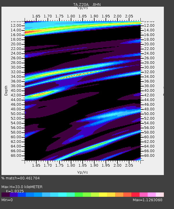
| Estimated Moho Depth: |
33.0 km |
| Estimated Crust Vp/Vs: |
1.83 |
| Assumed Crust Vp: |
6.276 km/s |
| Estimated Crust Vs: |
3.425 km/s |
| Estimated Crust Poisson's Ratio: |
0.29 |
|
| Radial Match: |
80.461784 % |
| Radial Bump: |
362 |
| Transverse Match: |
66.62502 % |
| Transverse Bump: |
400 |
| SOD ConfigId: |
2658 |
| Insert Time: |
2010-03-06 04:11:02.775 +0000 |
| GWidth: |
2.5 |
| Max Bumps: |
400 |
| Tol: |
0.001 |
|

Signal To Noise
| Channel | StoN | STA | LTA |
| TA:Z20A: :BHN:20090330T07:19:54.398988Z | 8.536884 | 1.3656096E-6 | 1.599658E-7 |
| TA:Z20A: :BHE:20090330T07:19:54.398988Z | 2.2946262 | 4.1114095E-7 | 1.7917556E-7 |
| TA:Z20A: :BHZ:20090330T07:19:54.398988Z | 3.4340248 | 4.97327E-7 | 1.4482335E-7 |
| Arrivals |
| Ps | 4.7 SECOND |
| PpPs | 14 SECOND |
| PsPs/PpSs | 19 SECOND |


