You are here: Home > Network List > AV - Alaska Volcano Observatory Stations List
> Station MAPS Pakushin Southeast, Makushin Volcano, Alaska > Earthquake Result Viewer
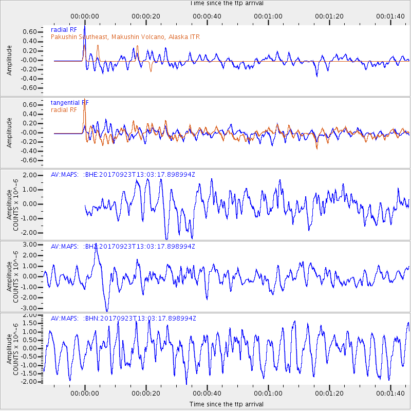
MAPS Pakushin Southeast, Makushin Volcano, Alaska - Earthquake Result Viewer
*The percent match for this event was below the threshold and hence no stack was calculated.
| Earthquake location: |
Oaxaca, Mexico |
| Earthquake latitude/longitude: |
16.7/-94.9 |
| Earthquake time(UTC): |
2017/09/23 (266) 12:53:02 GMT |
| Earthquake Depth: |
9.1 km |
| Earthquake Magnitude: |
6.1 Mww |
| Earthquake Catalog/Contributor: |
NEIC PDE/us |
|
| Network: |
AV Alaska Volcano Observatory |
| Station: |
MAPS Pakushin Southeast, Makushin Volcano, Alaska |
| Lat/Lon: |
53.81 N/166.94 W |
| Elevation: |
333 m |
|
| Distance: |
66.0 deg |
| Az: |
321.884 deg |
| Baz: |
94.305 deg |
| Ray Param: |
$rayparam |
*The percent match for this event was below the threshold and hence was not used in the summary stack. |
|
| Radial Match: |
52.524014 % |
| Radial Bump: |
400 |
| Transverse Match: |
52.71631 % |
| Transverse Bump: |
400 |
| SOD ConfigId: |
13570011 |
| Insert Time: |
2019-04-28 20:55:42.153 +0000 |
| GWidth: |
2.5 |
| Max Bumps: |
400 |
| Tol: |
0.001 |
|
Signal To Noise
| Channel | StoN | STA | LTA |
| AV:MAPS: :BHZ:20170923T13:03:17.898994Z | 2.743553 | 1.3824615E-6 | 5.0389457E-7 |
| AV:MAPS: :BHN:20170923T13:03:17.898994Z | 0.89073133 | 6.7746197E-7 | 7.6056824E-7 |
| AV:MAPS: :BHE:20170923T13:03:17.898994Z | 1.8509356 | 1.3316103E-6 | 7.1942554E-7 |
| Arrivals |
| Ps | |
| PpPs | |
| PsPs/PpSs | |


