You are here: Home > Network List > TA - USArray Transportable Network (new EarthScope stations) Stations List
> Station Z20A Nine Sixteen Ranch, Cliff, NM, USA > Earthquake Result Viewer
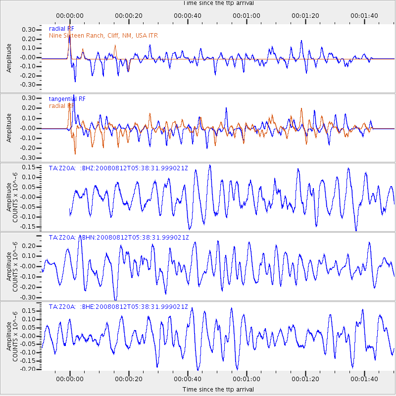
Z20A Nine Sixteen Ranch, Cliff, NM, USA - Earthquake Result Viewer
*The percent match for this event was below the threshold and hence no stack was calculated.
| Earthquake location: |
Santa Cruz Islands |
| Earthquake latitude/longitude: |
-11.4/166.2 |
| Earthquake time(UTC): |
2008/08/12 (225) 05:25:57 GMT |
| Earthquake Depth: |
38 km |
| Earthquake Magnitude: |
5.9 MW, 5.4 MS, 5.2 MB, 5.8 MW |
| Earthquake Catalog/Contributor: |
WHDF/NEIC |
|
| Network: |
TA USArray Transportable Network (new EarthScope stations) |
| Station: |
Z20A Nine Sixteen Ranch, Cliff, NM, USA |
| Lat/Lon: |
33.11 N/108.59 W |
| Elevation: |
1547 m |
|
| Distance: |
92.2 deg |
| Az: |
56.814 deg |
| Baz: |
257.864 deg |
| Ray Param: |
$rayparam |
*The percent match for this event was below the threshold and hence was not used in the summary stack. |
|
| Radial Match: |
70.96435 % |
| Radial Bump: |
393 |
| Transverse Match: |
71.6192 % |
| Transverse Bump: |
317 |
| SOD ConfigId: |
2504 |
| Insert Time: |
2010-03-06 04:11:30.825 +0000 |
| GWidth: |
2.5 |
| Max Bumps: |
400 |
| Tol: |
0.001 |
|
Signal To Noise
| Channel | StoN | STA | LTA |
| TA:Z20A: :BHN:20080812T05:38:31.999021Z | 2.8525205 | 1.5855328E-7 | 5.5583573E-8 |
| TA:Z20A: :BHE:20080812T05:38:31.999021Z | 0.9017915 | 4.301143E-8 | 4.7695533E-8 |
| TA:Z20A: :BHZ:20080812T05:38:31.999021Z | 1.3968464 | 6.2723736E-8 | 4.4903814E-8 |
| Arrivals |
| Ps | |
| PpPs | |
| PsPs/PpSs | |


