You are here: Home > Network List > CN - Canadian National Seismograph Network Stations List
> Station A61 Sainte Mathilde, QC, CA > Earthquake Result Viewer
A61 Sainte Mathilde, QC, CA - Earthquake Result Viewer
| Earthquake location: |
Oaxaca, Mexico |
| Earthquake latitude/longitude: |
16.7/-94.9 |
| Earthquake time(UTC): |
2017/09/23 (266) 12:53:02 GMT |
| Earthquake Depth: |
9.1 km |
| Earthquake Magnitude: |
6.1 Mww |
| Earthquake Catalog/Contributor: |
NEIC PDE/us |
|
| Network: |
CN Canadian National Seismograph Network |
| Station: |
A61 Sainte Mathilde, QC, CA |
| Lat/Lon: |
47.69 N/70.09 W |
| Elevation: |
380 m |
|
| Distance: |
37.0 deg |
| Az: |
28.141 deg |
| Baz: |
221.982 deg |
| Ray Param: |
0.07636821 |
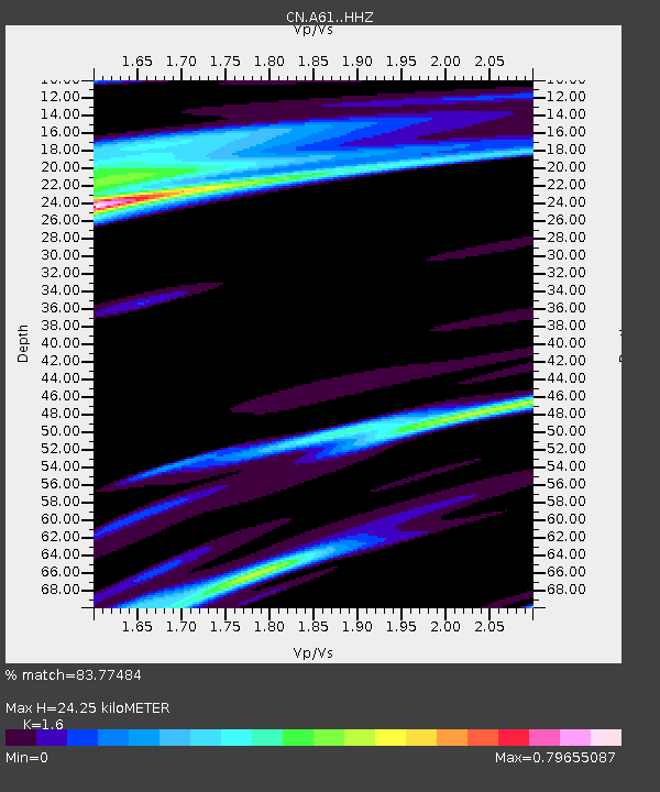
| Estimated Moho Depth: |
24.25 km |
| Estimated Crust Vp/Vs: |
1.60 |
| Assumed Crust Vp: |
6.61 km/s |
| Estimated Crust Vs: |
4.131 km/s |
| Estimated Crust Poisson's Ratio: |
0.18 |
|
| Radial Match: |
83.77484 % |
| Radial Bump: |
282 |
| Transverse Match: |
63.679363 % |
| Transverse Bump: |
388 |
| SOD ConfigId: |
13570011 |
| Insert Time: |
2019-04-28 20:57:22.392 +0000 |
| GWidth: |
2.5 |
| Max Bumps: |
400 |
| Tol: |
0.001 |
|

Signal To Noise
| Channel | StoN | STA | LTA |
| CN:A61: :HHZ:20170923T12:59:41.220009Z | 2.049789 | 1.0280196E-6 | 5.015246E-7 |
| CN:A61: :HHN:20170923T12:59:41.220009Z | 1.976778 | 8.719891E-7 | 4.4111633E-7 |
| CN:A61: :HHE:20170923T12:59:41.220009Z | 1.9022748 | 6.437414E-7 | 3.384061E-7 |
| Arrivals |
| Ps | 2.4 SECOND |
| PpPs | 8.7 SECOND |
| PsPs/PpSs | 11 SECOND |


