You are here: Home > Network List > TA - USArray Transportable Network (new EarthScope stations) Stations List
> Station F24K Squaw Lake, AK, USA > Earthquake Result Viewer
F24K Squaw Lake, AK, USA - Earthquake Result Viewer
| Earthquake location: |
Oaxaca, Mexico |
| Earthquake latitude/longitude: |
16.7/-94.9 |
| Earthquake time(UTC): |
2017/09/23 (266) 12:53:02 GMT |
| Earthquake Depth: |
9.1 km |
| Earthquake Magnitude: |
6.1 Mww |
| Earthquake Catalog/Contributor: |
NEIC PDE/us |
|
| Network: |
TA USArray Transportable Network (new EarthScope stations) |
| Station: |
F24K Squaw Lake, AK, USA |
| Lat/Lon: |
67.52 N/147.89 W |
| Elevation: |
736 m |
|
| Distance: |
60.9 deg |
| Az: |
339.436 deg |
| Baz: |
118.944 deg |
| Ray Param: |
0.06123225 |
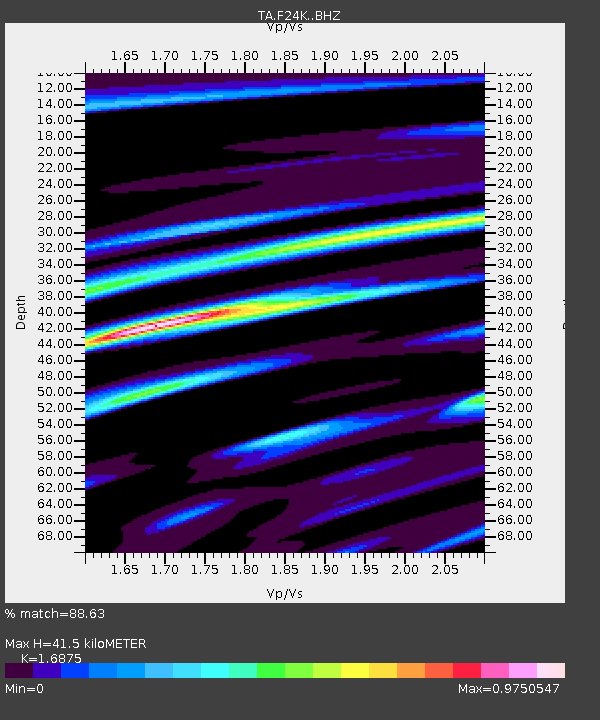
| Estimated Moho Depth: |
41.5 km |
| Estimated Crust Vp/Vs: |
1.69 |
| Assumed Crust Vp: |
6.522 km/s |
| Estimated Crust Vs: |
3.865 km/s |
| Estimated Crust Poisson's Ratio: |
0.23 |
|
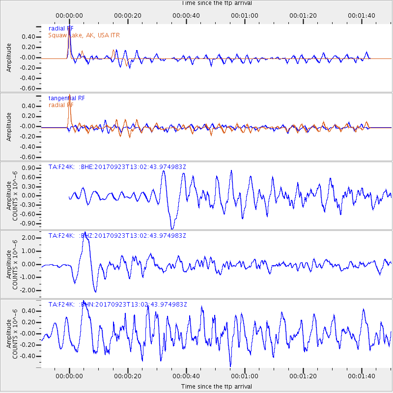
| Radial Match: |
88.63 % |
| Radial Bump: |
400 |
| Transverse Match: |
63.441673 % |
| Transverse Bump: |
400 |
| SOD ConfigId: |
13570011 |
| Insert Time: |
2019-04-28 21:01:03.253 +0000 |
| GWidth: |
2.5 |
| Max Bumps: |
400 |
| Tol: |
0.001 |
|
Signal To Noise
| Channel | StoN | STA | LTA |
| TA:F24K: :BHZ:20170923T13:02:43.974983Z | 6.508927 | 8.522492E-7 | 1.3093545E-7 |
| TA:F24K: :BHN:20170923T13:02:43.974983Z | 2.2085485 | 2.508459E-7 | 1.1357951E-7 |
| TA:F24K: :BHE:20170923T13:02:43.974983Z | 4.459996 | 4.86103E-7 | 1.08991784E-7 |
| Arrivals |
| Ps | 4.6 SECOND |
| PpPs | 16 SECOND |
| PsPs/PpSs | 21 SECOND |


