You are here: Home > Network List > TA - USArray Transportable Network (new EarthScope stations) Stations List
> Station G17K Kiwalik Mountain, AK, USA > Earthquake Result Viewer
G17K Kiwalik Mountain, AK, USA - Earthquake Result Viewer
| Earthquake location: |
Oaxaca, Mexico |
| Earthquake latitude/longitude: |
16.7/-94.9 |
| Earthquake time(UTC): |
2017/09/23 (266) 12:53:02 GMT |
| Earthquake Depth: |
9.1 km |
| Earthquake Magnitude: |
6.1 Mww |
| Earthquake Catalog/Contributor: |
NEIC PDE/us |
|
| Network: |
TA USArray Transportable Network (new EarthScope stations) |
| Station: |
G17K Kiwalik Mountain, AK, USA |
| Lat/Lon: |
65.50 N/160.65 W |
| Elevation: |
338 m |
|
| Distance: |
64.9 deg |
| Az: |
335.178 deg |
| Baz: |
105.298 deg |
| Ray Param: |
0.058646653 |
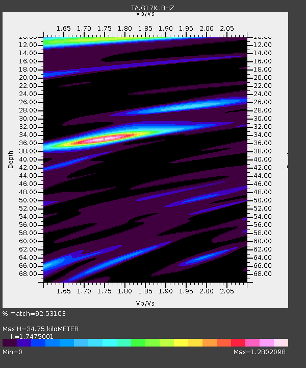
| Estimated Moho Depth: |
34.75 km |
| Estimated Crust Vp/Vs: |
1.75 |
| Assumed Crust Vp: |
6.276 km/s |
| Estimated Crust Vs: |
3.591 km/s |
| Estimated Crust Poisson's Ratio: |
0.26 |
|
| Radial Match: |
92.53103 % |
| Radial Bump: |
390 |
| Transverse Match: |
77.53271 % |
| Transverse Bump: |
400 |
| SOD ConfigId: |
13570011 |
| Insert Time: |
2019-04-28 21:01:08.847 +0000 |
| GWidth: |
2.5 |
| Max Bumps: |
400 |
| Tol: |
0.001 |
|

Signal To Noise
| Channel | StoN | STA | LTA |
| TA:G17K: :BHZ:20170923T13:03:10.375007Z | 12.823402 | 1.2650333E-6 | 9.865037E-8 |
| TA:G17K: :BHN:20170923T13:03:10.375007Z | 2.0572448 | 1.3101103E-7 | 6.368276E-8 |
| TA:G17K: :BHE:20170923T13:03:10.375007Z | 4.4839993 | 4.856702E-7 | 1.08311845E-7 |
| Arrivals |
| Ps | 4.3 SECOND |
| PpPs | 15 SECOND |
| PsPs/PpSs | 19 SECOND |


