You are here: Home > Network List > TA - USArray Transportable Network (new EarthScope stations) Stations List
> Station K13K Kusilvak Mountain, AK, USA > Earthquake Result Viewer
K13K Kusilvak Mountain, AK, USA - Earthquake Result Viewer
| Earthquake location: |
Oaxaca, Mexico |
| Earthquake latitude/longitude: |
16.7/-94.9 |
| Earthquake time(UTC): |
2017/09/23 (266) 12:53:02 GMT |
| Earthquake Depth: |
9.1 km |
| Earthquake Magnitude: |
6.1 Mww |
| Earthquake Catalog/Contributor: |
NEIC PDE/us |
|
| Network: |
TA USArray Transportable Network (new EarthScope stations) |
| Station: |
K13K Kusilvak Mountain, AK, USA |
| Lat/Lon: |
61.93 N/164.66 W |
| Elevation: |
204 m |
|
| Distance: |
65.8 deg |
| Az: |
330.906 deg |
| Baz: |
99.927 deg |
| Ray Param: |
0.05801729 |
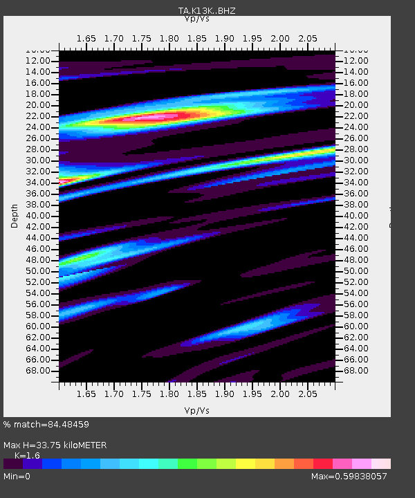
| Estimated Moho Depth: |
33.75 km |
| Estimated Crust Vp/Vs: |
1.60 |
| Assumed Crust Vp: |
6.1 km/s |
| Estimated Crust Vs: |
3.812 km/s |
| Estimated Crust Poisson's Ratio: |
0.18 |
|
| Radial Match: |
84.48459 % |
| Radial Bump: |
400 |
| Transverse Match: |
66.19724 % |
| Transverse Bump: |
400 |
| SOD ConfigId: |
13570011 |
| Insert Time: |
2019-04-28 21:01:44.664 +0000 |
| GWidth: |
2.5 |
| Max Bumps: |
400 |
| Tol: |
0.001 |
|
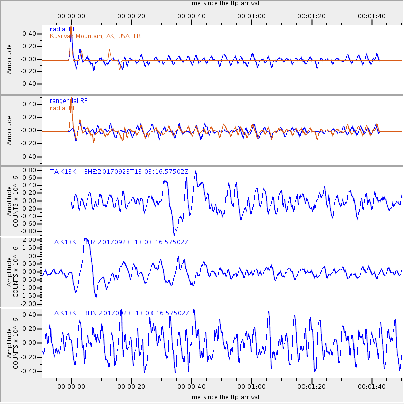
Signal To Noise
| Channel | StoN | STA | LTA |
| TA:K13K: :BHZ:20170923T13:03:16.57502Z | 7.845678 | 9.753426E-7 | 1.2431592E-7 |
| TA:K13K: :BHN:20170923T13:03:16.57502Z | 1.2932786 | 1.8558599E-7 | 1.435004E-7 |
| TA:K13K: :BHE:20170923T13:03:16.57502Z | 3.6257045 | 4.4824492E-7 | 1.2362975E-7 |
| Arrivals |
| Ps | 3.5 SECOND |
| PpPs | 14 SECOND |
| PsPs/PpSs | 17 SECOND |


