You are here: Home > Network List > TA - USArray Transportable Network (new EarthScope stations) Stations List
> Station K24K Donnelly Dome, AK, USA > Earthquake Result Viewer
K24K Donnelly Dome, AK, USA - Earthquake Result Viewer
| Earthquake location: |
Oaxaca, Mexico |
| Earthquake latitude/longitude: |
16.7/-94.9 |
| Earthquake time(UTC): |
2017/09/23 (266) 12:53:02 GMT |
| Earthquake Depth: |
9.1 km |
| Earthquake Magnitude: |
6.1 Mww |
| Earthquake Catalog/Contributor: |
NEIC PDE/us |
|
| Network: |
TA USArray Transportable Network (new EarthScope stations) |
| Station: |
K24K Donnelly Dome, AK, USA |
| Lat/Lon: |
63.80 N/145.78 W |
| Elevation: |
724 m |
|
| Distance: |
58.3 deg |
| Az: |
336.148 deg |
| Baz: |
119.2 deg |
| Ray Param: |
0.06292506 |
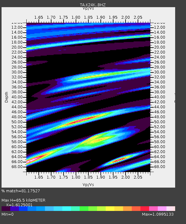
| Estimated Moho Depth: |
65.5 km |
| Estimated Crust Vp/Vs: |
1.61 |
| Assumed Crust Vp: |
6.566 km/s |
| Estimated Crust Vs: |
4.072 km/s |
| Estimated Crust Poisson's Ratio: |
0.19 |
|
| Radial Match: |
81.17527 % |
| Radial Bump: |
400 |
| Transverse Match: |
71.767876 % |
| Transverse Bump: |
400 |
| SOD ConfigId: |
13570011 |
| Insert Time: |
2019-04-28 21:01:47.263 +0000 |
| GWidth: |
2.5 |
| Max Bumps: |
400 |
| Tol: |
0.001 |
|

Signal To Noise
| Channel | StoN | STA | LTA |
| TA:K24K: :BHZ:20170923T13:02:26.224983Z | 4.429059 | 1.3540422E-6 | 3.057178E-7 |
| TA:K24K: :BHN:20170923T13:02:26.224983Z | 1.2057978 | 3.9406717E-7 | 3.2681032E-7 |
| TA:K24K: :BHE:20170923T13:02:26.224983Z | 1.314198 | 5.4074746E-7 | 4.1146575E-7 |
| Arrivals |
| Ps | 6.5 SECOND |
| PpPs | 25 SECOND |
| PsPs/PpSs | 31 SECOND |


