You are here: Home > Network List > TA - USArray Transportable Network (new EarthScope stations) Stations List
> Station O18K Koktuh Hills, AK, USA > Earthquake Result Viewer
O18K Koktuh Hills, AK, USA - Earthquake Result Viewer
| Earthquake location: |
Oaxaca, Mexico |
| Earthquake latitude/longitude: |
16.7/-94.9 |
| Earthquake time(UTC): |
2017/09/23 (266) 12:53:02 GMT |
| Earthquake Depth: |
9.1 km |
| Earthquake Magnitude: |
6.1 Mww |
| Earthquake Catalog/Contributor: |
NEIC PDE/us |
|
| Network: |
TA USArray Transportable Network (new EarthScope stations) |
| Station: |
O18K Koktuh Hills, AK, USA |
| Lat/Lon: |
59.85 N/155.21 W |
| Elevation: |
544 m |
|
| Distance: |
60.8 deg |
| Az: |
329.88 deg |
| Baz: |
107.714 deg |
| Ray Param: |
0.061262216 |
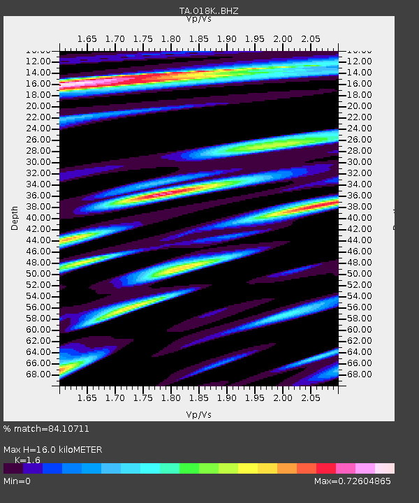
| Estimated Moho Depth: |
16.0 km |
| Estimated Crust Vp/Vs: |
1.60 |
| Assumed Crust Vp: |
6.438 km/s |
| Estimated Crust Vs: |
4.024 km/s |
| Estimated Crust Poisson's Ratio: |
0.18 |
|
| Radial Match: |
84.10711 % |
| Radial Bump: |
400 |
| Transverse Match: |
68.49345 % |
| Transverse Bump: |
400 |
| SOD ConfigId: |
13570011 |
| Insert Time: |
2019-04-28 21:02:26.031 +0000 |
| GWidth: |
2.5 |
| Max Bumps: |
400 |
| Tol: |
0.001 |
|

Signal To Noise
| Channel | StoN | STA | LTA |
| TA:O18K: :BHZ:20170923T13:02:43.674995Z | 9.671688 | 1.5156161E-6 | 1.5670646E-7 |
| TA:O18K: :BHN:20170923T13:02:43.674995Z | 3.1992562 | 3.9013975E-7 | 1.2194701E-7 |
| TA:O18K: :BHE:20170923T13:02:43.674995Z | 3.519254 | 6.7895326E-7 | 1.9292534E-7 |
| Arrivals |
| Ps | 1.6 SECOND |
| PpPs | 6.1 SECOND |
| PsPs/PpSs | 7.7 SECOND |


