You are here: Home > Network List > IU - Global Seismograph Network (GSN - IRIS/USGS) Stations List
> Station RSSD Black Hills, South Dakota, USA > Earthquake Result Viewer
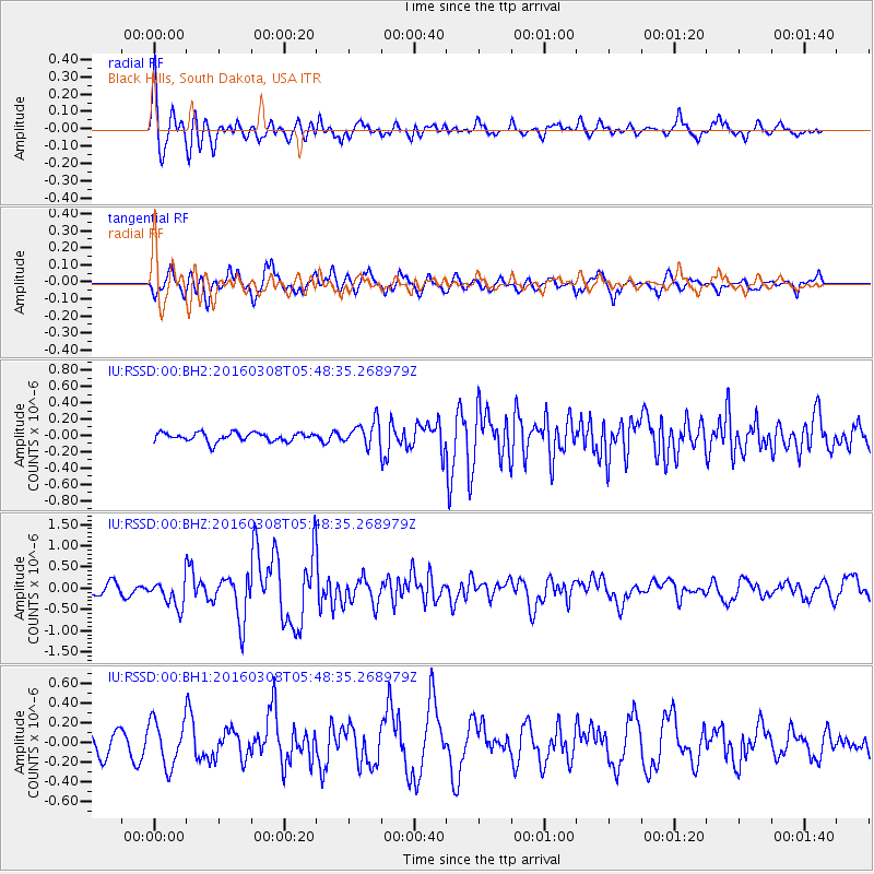
RSSD Black Hills, South Dakota, USA - Earthquake Result Viewer
*The percent match for this event was below the threshold and hence no stack was calculated.
| Earthquake location: |
Tonga Islands |
| Earthquake latitude/longitude: |
-15.1/-173.4 |
| Earthquake time(UTC): |
2016/03/08 (068) 05:36:27 GMT |
| Earthquake Depth: |
30 km |
| Earthquake Magnitude: |
5.8 MB |
| Earthquake Catalog/Contributor: |
NEIC PDE/NEIC COMCAT |
|
| Network: |
IU Global Seismograph Network (GSN - IRIS/USGS) |
| Station: |
RSSD Black Hills, South Dakota, USA |
| Lat/Lon: |
44.12 N/104.04 W |
| Elevation: |
2090 m |
|
| Distance: |
86.3 deg |
| Az: |
42.491 deg |
| Baz: |
244.924 deg |
| Ray Param: |
$rayparam |
*The percent match for this event was below the threshold and hence was not used in the summary stack. |
|
| Radial Match: |
79.097626 % |
| Radial Bump: |
400 |
| Transverse Match: |
72.81786 % |
| Transverse Bump: |
400 |
| SOD ConfigId: |
1453031 |
| Insert Time: |
2016-03-22 06:16:49.348 +0000 |
| GWidth: |
2.5 |
| Max Bumps: |
400 |
| Tol: |
0.001 |
|
Signal To Noise
| Channel | StoN | STA | LTA |
| IU:RSSD:00:BHZ:20160308T05:48:35.268979Z | 1.7864567 | 3.2272033E-7 | 1.8064827E-7 |
| IU:RSSD:00:BH1:20160308T05:48:35.268979Z | 1.7509184 | 2.326227E-7 | 1.3285754E-7 |
| IU:RSSD:00:BH2:20160308T05:48:35.268979Z | 2.7328289 | 1.473829E-7 | 5.393053E-8 |
| Arrivals |
| Ps | |
| PpPs | |
| PsPs/PpSs | |


