You are here: Home > Network List > UO - University of Oregon Regional Network Stations List
> Station FHAC Terrebonne, OR, USA > Earthquake Result Viewer
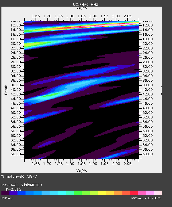
FHAC Terrebonne, OR, USA - Earthquake Result Viewer
| Earthquake location: |
Oaxaca, Mexico |
| Earthquake latitude/longitude: |
16.7/-94.9 |
| Earthquake time(UTC): |
2017/09/23 (266) 12:53:02 GMT |
| Earthquake Depth: |
9.1 km |
| Earthquake Magnitude: |
6.1 Mww |
| Earthquake Catalog/Contributor: |
NEIC PDE/us |
|
| Network: |
UO University of Oregon Regional Network |
| Station: |
FHAC Terrebonne, OR, USA |
| Lat/Lon: |
44.34 N/121.34 W |
| Elevation: |
811 m |
|
| Distance: |
35.4 deg |
| Az: |
326.571 deg |
| Baz: |
132.644 deg |
| Ray Param: |
0.077255525 |
| Estimated Moho Depth: |
11.5 km |
| Estimated Crust Vp/Vs: |
2.02 |
| Assumed Crust Vp: |
6.597 km/s |
| Estimated Crust Vs: |
3.274 km/s |
| Estimated Crust Poisson's Ratio: |
0.34 |
|
| Radial Match: |
80.73877 % |
| Radial Bump: |
295 |
| Transverse Match: |
70.89813 % |
| Transverse Bump: |
400 |
| SOD ConfigId: |
13570011 |
| Insert Time: |
2019-04-28 21:03:06.860 +0000 |
| GWidth: |
2.5 |
| Max Bumps: |
400 |
| Tol: |
0.001 |
|

Signal To Noise
| Channel | StoN | STA | LTA |
| UO:FHAC: :HHZ:20170923T12:59:27.247993Z | 6.68864 | 1.320072E-6 | 1.973603E-7 |
| UO:FHAC: :HHN:20170923T12:59:27.247993Z | 1.5544139 | 3.950699E-7 | 2.5416003E-7 |
| UO:FHAC: :HHE:20170923T12:59:27.247993Z | 1.3826883 | 4.691063E-7 | 3.392712E-7 |
| Arrivals |
| Ps | 1.9 SECOND |
| PpPs | 4.9 SECOND |
| PsPs/PpSs | 6.8 SECOND |


