You are here: Home > Network List > TA - USArray Transportable Network (new EarthScope stations) Stations List
> Station Z20A Nine Sixteen Ranch, Cliff, NM, USA > Earthquake Result Viewer
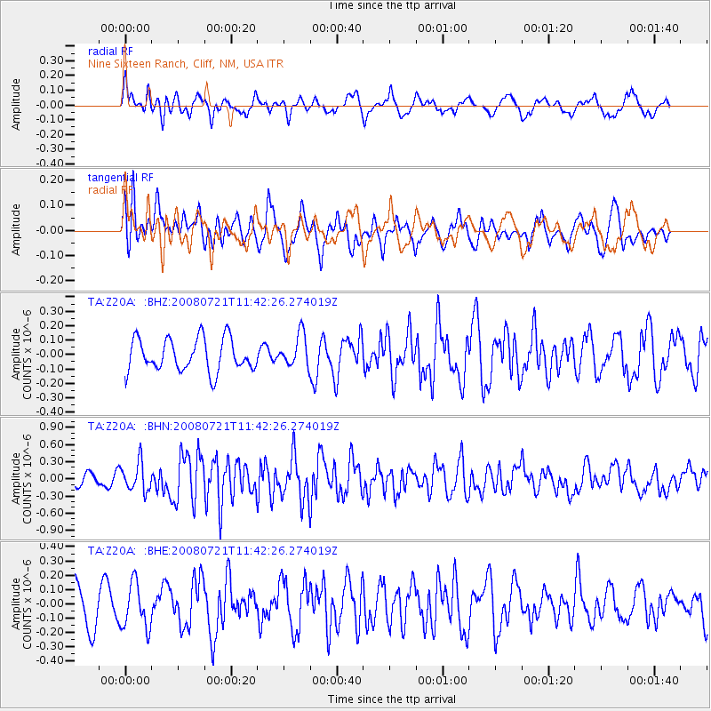
Z20A Nine Sixteen Ranch, Cliff, NM, USA - Earthquake Result Viewer
*The percent match for this event was below the threshold and hence no stack was calculated.
| Earthquake location: |
Off East Coast Of Honshu, Japan |
| Earthquake latitude/longitude: |
37.2/142.1 |
| Earthquake time(UTC): |
2008/07/21 (203) 11:30:29 GMT |
| Earthquake Depth: |
22 km |
| Earthquake Magnitude: |
5.7 MB, 5.6 MS, 6.0 MW, 5.9 MW |
| Earthquake Catalog/Contributor: |
WHDF/NEIC |
|
| Network: |
TA USArray Transportable Network (new EarthScope stations) |
| Station: |
Z20A Nine Sixteen Ranch, Cliff, NM, USA |
| Lat/Lon: |
33.11 N/108.59 W |
| Elevation: |
1547 m |
|
| Distance: |
84.0 deg |
| Az: |
52.772 deg |
| Baz: |
310.74 deg |
| Ray Param: |
$rayparam |
*The percent match for this event was below the threshold and hence was not used in the summary stack. |
|
| Radial Match: |
57.53208 % |
| Radial Bump: |
400 |
| Transverse Match: |
51.431984 % |
| Transverse Bump: |
400 |
| SOD ConfigId: |
2504 |
| Insert Time: |
2010-03-06 04:15:06.565 +0000 |
| GWidth: |
2.5 |
| Max Bumps: |
400 |
| Tol: |
0.001 |
|
Signal To Noise
| Channel | StoN | STA | LTA |
| TA:Z20A: :BHN:20080721T11:42:26.274019Z | 2.9814909 | 2.5202817E-7 | 8.453092E-8 |
| TA:Z20A: :BHE:20080721T11:42:26.274019Z | 1.195411 | 1.5909679E-7 | 1.3308961E-7 |
| TA:Z20A: :BHZ:20080721T11:42:26.274019Z | 1.0141428 | 1.1365015E-7 | 1.1206525E-7 |
| Arrivals |
| Ps | |
| PpPs | |
| PsPs/PpSs | |


