You are here: Home > Network List > AV - Alaska Volcano Observatory Stations List
> Station SPCR Ckakachatna River, Mount Spurr, Alaska > Earthquake Result Viewer
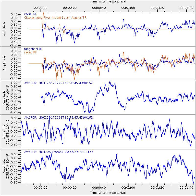
SPCR Ckakachatna River, Mount Spurr, Alaska - Earthquake Result Viewer
*The percent match for this event was below the threshold and hence no stack was calculated.
| Earthquake location: |
Mindanao, Philippines |
| Earthquake latitude/longitude: |
7.6/124.9 |
| Earthquake time(UTC): |
2017/09/23 (266) 20:47:08 GMT |
| Earthquake Depth: |
31 km |
| Earthquake Magnitude: |
5.7 Mww |
| Earthquake Catalog/Contributor: |
NEIC PDE/us |
|
| Network: |
AV Alaska Volcano Observatory |
| Station: |
SPCR Ckakachatna River, Mount Spurr, Alaska |
| Lat/Lon: |
61.20 N/152.21 W |
| Elevation: |
984 m |
|
| Distance: |
79.9 deg |
| Az: |
29.212 deg |
| Baz: |
267.492 deg |
| Ray Param: |
$rayparam |
*The percent match for this event was below the threshold and hence was not used in the summary stack. |
|
| Radial Match: |
36.23555 % |
| Radial Bump: |
353 |
| Transverse Match: |
43.659843 % |
| Transverse Bump: |
400 |
| SOD ConfigId: |
13570011 |
| Insert Time: |
2019-04-28 21:05:24.297 +0000 |
| GWidth: |
2.5 |
| Max Bumps: |
400 |
| Tol: |
0.001 |
|
Signal To Noise
| Channel | StoN | STA | LTA |
| AV:SPCR: :BHZ:20170923T20:58:45.439016Z | 1.3832077 | 2.7120961E-7 | 1.9607296E-7 |
| AV:SPCR: :BHN:20170923T20:58:45.439016Z | 2.9119062 | 3.8546773E-7 | 1.3237641E-7 |
| AV:SPCR: :BHE:20170923T20:58:45.439016Z | 3.7566385 | 8.954516E-7 | 2.3836512E-7 |
| Arrivals |
| Ps | |
| PpPs | |
| PsPs/PpSs | |


