You are here: Home > Network List > TA - USArray Transportable Network (new EarthScope stations) Stations List
> Station 223A Chaparral, Anthony, NM, USA > Earthquake Result Viewer
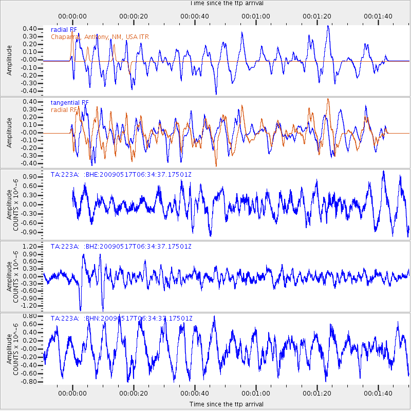
223A Chaparral, Anthony, NM, USA - Earthquake Result Viewer
*The percent match for this event was below the threshold and hence no stack was calculated.
| Earthquake location: |
Tonga Islands |
| Earthquake latitude/longitude: |
-16.8/-173.5 |
| Earthquake time(UTC): |
2009/05/17 (137) 06:23:03 GMT |
| Earthquake Depth: |
67 km |
| Earthquake Magnitude: |
5.5 MB, 5.6 MW, 5.6 MW |
| Earthquake Catalog/Contributor: |
WHDF/NEIC |
|
| Network: |
TA USArray Transportable Network (new EarthScope stations) |
| Station: |
223A Chaparral, Anthony, NM, USA |
| Lat/Lon: |
32.01 N/106.43 W |
| Elevation: |
1232 m |
|
| Distance: |
80.5 deg |
| Az: |
52.498 deg |
| Baz: |
243.421 deg |
| Ray Param: |
$rayparam |
*The percent match for this event was below the threshold and hence was not used in the summary stack. |
|
| Radial Match: |
60.4841 % |
| Radial Bump: |
400 |
| Transverse Match: |
42.83317 % |
| Transverse Bump: |
365 |
| SOD ConfigId: |
2760 |
| Insert Time: |
2010-03-06 04:15:43.865 +0000 |
| GWidth: |
2.5 |
| Max Bumps: |
400 |
| Tol: |
0.001 |
|
Signal To Noise
| Channel | StoN | STA | LTA |
| TA:223A: :BHZ:20090517T06:34:37.17501Z | 4.9631815 | 5.335047E-7 | 1.0749249E-7 |
| TA:223A: :BHN:20090517T06:34:37.17501Z | 0.84423274 | 2.2282047E-7 | 2.6393252E-7 |
| TA:223A: :BHE:20090517T06:34:37.17501Z | 1.0107121 | 2.2801875E-7 | 2.2560208E-7 |
| Arrivals |
| Ps | |
| PpPs | |
| PsPs/PpSs | |


