You are here: Home > Network List > TA - USArray Transportable Network (new EarthScope stations) Stations List
> Station F20K Avaraart Lake, AK, USA > Earthquake Result Viewer
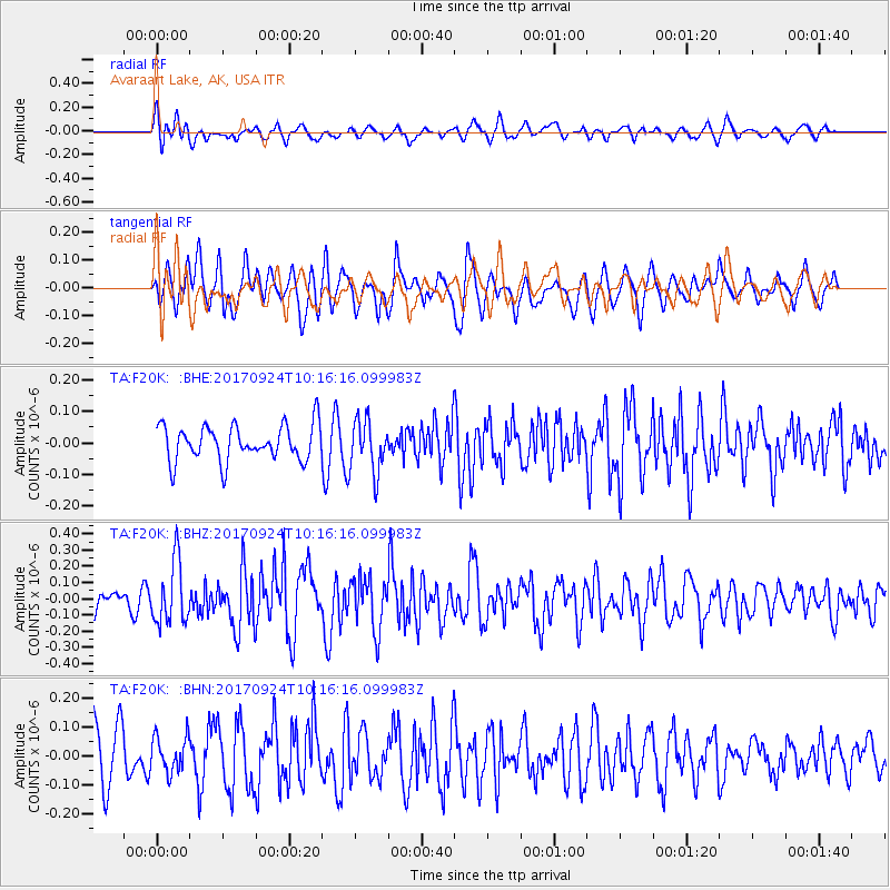
F20K Avaraart Lake, AK, USA - Earthquake Result Viewer
*The percent match for this event was below the threshold and hence no stack was calculated.
| Earthquake location: |
Near Coast Of Oaxaca, Mexico |
| Earthquake latitude/longitude: |
15.3/-94.1 |
| Earthquake time(UTC): |
2017/09/24 (267) 10:06:12 GMT |
| Earthquake Depth: |
55 km |
| Earthquake Magnitude: |
5.8 Mww |
| Earthquake Catalog/Contributor: |
NEIC PDE/us |
|
| Network: |
TA USArray Transportable Network (new EarthScope stations) |
| Station: |
F20K Avaraart Lake, AK, USA |
| Lat/Lon: |
67.05 N/155.73 W |
| Elevation: |
136 m |
|
| Distance: |
65.1 deg |
| Az: |
337.634 deg |
| Baz: |
110.579 deg |
| Ray Param: |
$rayparam |
*The percent match for this event was below the threshold and hence was not used in the summary stack. |
|
| Radial Match: |
54.011612 % |
| Radial Bump: |
400 |
| Transverse Match: |
53.50183 % |
| Transverse Bump: |
400 |
| SOD ConfigId: |
13570011 |
| Insert Time: |
2019-04-28 21:11:47.118 +0000 |
| GWidth: |
2.5 |
| Max Bumps: |
400 |
| Tol: |
0.001 |
|
Signal To Noise
| Channel | StoN | STA | LTA |
| TA:F20K: :BHZ:20170924T10:16:16.099983Z | 3.2977314 | 1.9288156E-7 | 5.8489164E-8 |
| TA:F20K: :BHN:20170924T10:16:16.099983Z | 0.65211844 | 6.1428004E-8 | 9.419762E-8 |
| TA:F20K: :BHE:20170924T10:16:16.099983Z | 1.4993078 | 8.409373E-8 | 5.608837E-8 |
| Arrivals |
| Ps | |
| PpPs | |
| PsPs/PpSs | |


