You are here: Home > Network List > TA - USArray Transportable Network (new EarthScope stations) Stations List
> Station R33M Jennings River, BC, CAN > Earthquake Result Viewer
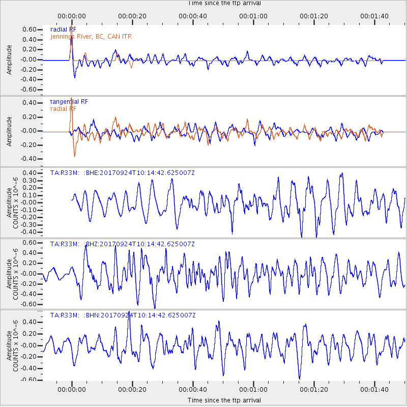
R33M Jennings River, BC, CAN - Earthquake Result Viewer
*The percent match for this event was below the threshold and hence no stack was calculated.
| Earthquake location: |
Near Coast Of Oaxaca, Mexico |
| Earthquake latitude/longitude: |
15.3/-94.1 |
| Earthquake time(UTC): |
2017/09/24 (267) 10:06:12 GMT |
| Earthquake Depth: |
55 km |
| Earthquake Magnitude: |
5.8 Mww |
| Earthquake Catalog/Contributor: |
NEIC PDE/us |
|
| Network: |
TA USArray Transportable Network (new EarthScope stations) |
| Station: |
R33M Jennings River, BC, CAN |
| Lat/Lon: |
59.39 N/130.97 W |
| Elevation: |
1437 m |
|
| Distance: |
51.6 deg |
| Az: |
336.949 deg |
| Baz: |
132.409 deg |
| Ray Param: |
$rayparam |
*The percent match for this event was below the threshold and hence was not used in the summary stack. |
|
| Radial Match: |
72.39155 % |
| Radial Bump: |
400 |
| Transverse Match: |
50.93407 % |
| Transverse Bump: |
330 |
| SOD ConfigId: |
13570011 |
| Insert Time: |
2019-04-28 21:12:23.159 +0000 |
| GWidth: |
2.5 |
| Max Bumps: |
400 |
| Tol: |
0.001 |
|
Signal To Noise
| Channel | StoN | STA | LTA |
| TA:R33M: :BHZ:20170924T10:14:42.625007Z | 2.5840452 | 2.7250508E-7 | 1.0545678E-7 |
| TA:R33M: :BHN:20170924T10:14:42.625007Z | 1.3913845 | 1.7028182E-7 | 1.2238301E-7 |
| TA:R33M: :BHE:20170924T10:14:42.625007Z | 1.5531025 | 1.9278633E-7 | 1.2412981E-7 |
| Arrivals |
| Ps | |
| PpPs | |
| PsPs/PpSs | |


