You are here: Home > Network List > TA - USArray Transportable Network (new EarthScope stations) Stations List
> Station 223A Chaparral, Anthony, NM, USA > Earthquake Result Viewer
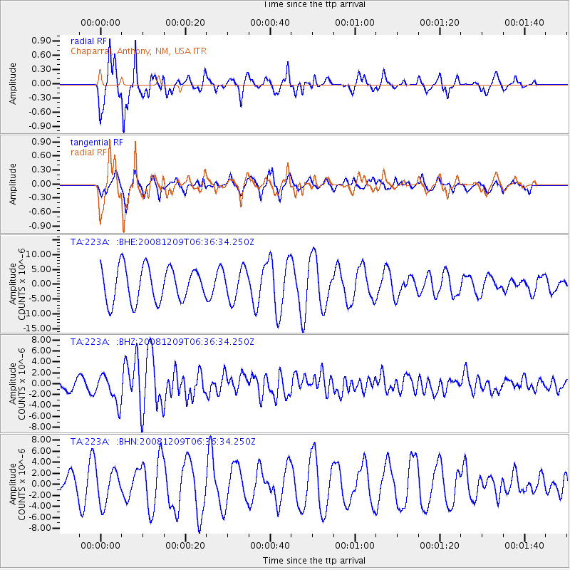
223A Chaparral, Anthony, NM, USA - Earthquake Result Viewer
*The percent match for this event was below the threshold and hence no stack was calculated.
| Earthquake location: |
Kermadec Islands Region |
| Earthquake latitude/longitude: |
-31.2/-176.9 |
| Earthquake time(UTC): |
2008/12/09 (344) 06:23:59 GMT |
| Earthquake Depth: |
18 km |
| Earthquake Magnitude: |
6.2 MB, 6.7 MS, 6.8 MW, 6.7 MW |
| Earthquake Catalog/Contributor: |
WHDF/NEIC |
|
| Network: |
TA USArray Transportable Network (new EarthScope stations) |
| Station: |
223A Chaparral, Anthony, NM, USA |
| Lat/Lon: |
32.01 N/106.43 W |
| Elevation: |
1232 m |
|
| Distance: |
91.7 deg |
| Az: |
53.243 deg |
| Baz: |
233.882 deg |
| Ray Param: |
$rayparam |
*The percent match for this event was below the threshold and hence was not used in the summary stack. |
|
| Radial Match: |
89.02401 % |
| Radial Bump: |
325 |
| Transverse Match: |
67.73678 % |
| Transverse Bump: |
360 |
| SOD ConfigId: |
2658 |
| Insert Time: |
2010-03-06 04:16:56.376 +0000 |
| GWidth: |
2.5 |
| Max Bumps: |
400 |
| Tol: |
0.001 |
|
Signal To Noise
| Channel | StoN | STA | LTA |
| TA:223A: :BHZ:20081209T06:36:34.250Z | 1.9066335 | 2.6628163E-6 | 1.3966063E-6 |
| TA:223A: :BHN:20081209T06:36:34.250Z | 1.6400919 | 2.9971234E-6 | 1.8274119E-6 |
| TA:223A: :BHE:20081209T06:36:34.250Z | 0.9021583 | 5.197758E-6 | 5.76147E-6 |
| Arrivals |
| Ps | |
| PpPs | |
| PsPs/PpSs | |


