You are here: Home > Network List > US - United States National Seismic Network Stations List
> Station MIAR Mount Ida, Arkansas, USA > Earthquake Result Viewer
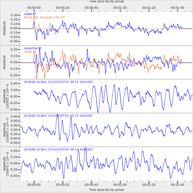
MIAR Mount Ida, Arkansas, USA - Earthquake Result Viewer
*The percent match for this event was below the threshold and hence no stack was calculated.
| Earthquake location: |
Tonga Islands |
| Earthquake latitude/longitude: |
-15.1/-173.4 |
| Earthquake time(UTC): |
2016/03/08 (068) 05:36:27 GMT |
| Earthquake Depth: |
30 km |
| Earthquake Magnitude: |
5.8 MB |
| Earthquake Catalog/Contributor: |
NEIC PDE/NEIC COMCAT |
|
| Network: |
US United States National Seismic Network |
| Station: |
MIAR Mount Ida, Arkansas, USA |
| Lat/Lon: |
34.55 N/93.58 W |
| Elevation: |
207 m |
|
| Distance: |
90.3 deg |
| Az: |
54.342 deg |
| Baz: |
251.912 deg |
| Ray Param: |
$rayparam |
*The percent match for this event was below the threshold and hence was not used in the summary stack. |
|
| Radial Match: |
58.27403 % |
| Radial Bump: |
400 |
| Transverse Match: |
51.894867 % |
| Transverse Bump: |
400 |
| SOD ConfigId: |
1453031 |
| Insert Time: |
2016-03-22 06:26:16.494 +0000 |
| GWidth: |
2.5 |
| Max Bumps: |
400 |
| Tol: |
0.001 |
|
Signal To Noise
| Channel | StoN | STA | LTA |
| US:MIAR:00:BHZ:20160308T05:48:54.499998Z | 1.0410663 | 1.9171637E-7 | 1.8415386E-7 |
| US:MIAR:00:BH1:20160308T05:48:54.499998Z | 1.1035354 | 1.558645E-7 | 1.4124105E-7 |
| US:MIAR:00:BH2:20160308T05:48:54.499998Z | 1.589567 | 1.8622693E-7 | 1.17155764E-7 |
| Arrivals |
| Ps | |
| PpPs | |
| PsPs/PpSs | |


