You are here: Home > Network List > TA - USArray Transportable Network (new EarthScope stations) Stations List
> Station F21K Alatna River, AK, USA > Earthquake Result Viewer
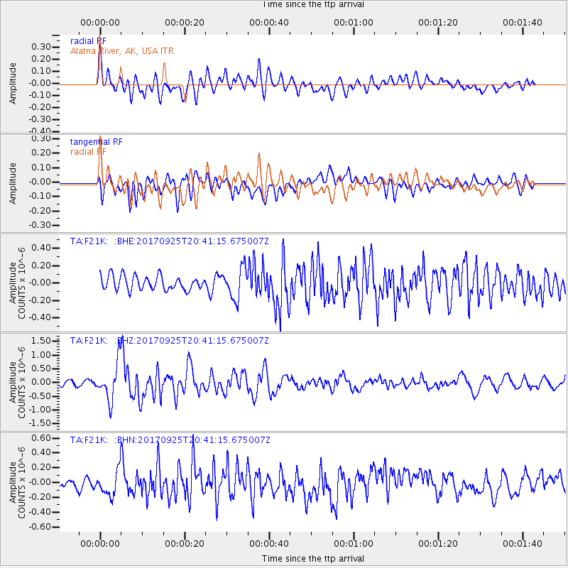
F21K Alatna River, AK, USA - Earthquake Result Viewer
*The percent match for this event was below the threshold and hence no stack was calculated.
| Earthquake location: |
New Britain Region, P.N.G. |
| Earthquake latitude/longitude: |
-6.2/152.7 |
| Earthquake time(UTC): |
2017/09/25 (268) 20:29:23 GMT |
| Earthquake Depth: |
6.0 km |
| Earthquake Magnitude: |
5.9 Mww |
| Earthquake Catalog/Contributor: |
NEIC PDE/us |
|
| Network: |
TA USArray Transportable Network (new EarthScope stations) |
| Station: |
F21K Alatna River, AK, USA |
| Lat/Lon: |
67.22 N/153.48 W |
| Elevation: |
597 m |
|
| Distance: |
82.6 deg |
| Az: |
18.475 deg |
| Baz: |
234.013 deg |
| Ray Param: |
$rayparam |
*The percent match for this event was below the threshold and hence was not used in the summary stack. |
|
| Radial Match: |
68.82212 % |
| Radial Bump: |
400 |
| Transverse Match: |
66.95568 % |
| Transverse Bump: |
400 |
| SOD ConfigId: |
13570011 |
| Insert Time: |
2019-04-28 21:19:28.882 +0000 |
| GWidth: |
2.5 |
| Max Bumps: |
400 |
| Tol: |
0.001 |
|
Signal To Noise
| Channel | StoN | STA | LTA |
| TA:F21K: :BHZ:20170925T20:41:15.675007Z | 7.4008365 | 6.9946134E-7 | 9.451112E-8 |
| TA:F21K: :BHN:20170925T20:41:15.675007Z | 1.9305743 | 1.7856085E-7 | 9.249106E-8 |
| TA:F21K: :BHE:20170925T20:41:15.675007Z | 2.2461114 | 1.8005353E-7 | 8.016233E-8 |
| Arrivals |
| Ps | |
| PpPs | |
| PsPs/PpSs | |


