You are here: Home > Network List > TA - USArray Transportable Network (new EarthScope stations) Stations List
> Station G31M Satah River, YT, CAN > Earthquake Result Viewer
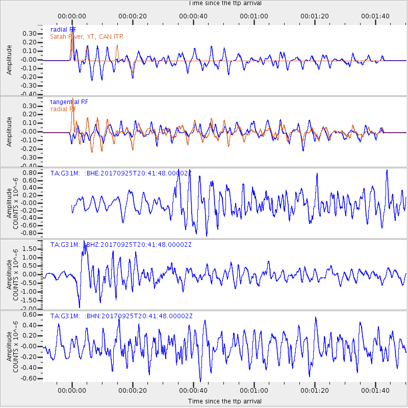
G31M Satah River, YT, CAN - Earthquake Result Viewer
*The percent match for this event was below the threshold and hence no stack was calculated.
| Earthquake location: |
New Britain Region, P.N.G. |
| Earthquake latitude/longitude: |
-6.2/152.7 |
| Earthquake time(UTC): |
2017/09/25 (268) 20:29:23 GMT |
| Earthquake Depth: |
6.0 km |
| Earthquake Magnitude: |
5.9 Mww |
| Earthquake Catalog/Contributor: |
NEIC PDE/us |
|
| Network: |
TA USArray Transportable Network (new EarthScope stations) |
| Station: |
G31M Satah River, YT, CAN |
| Lat/Lon: |
66.92 N/134.27 W |
| Elevation: |
61 m |
|
| Distance: |
89.1 deg |
| Az: |
22.152 deg |
| Baz: |
251.983 deg |
| Ray Param: |
$rayparam |
*The percent match for this event was below the threshold and hence was not used in the summary stack. |
|
| Radial Match: |
77.32602 % |
| Radial Bump: |
386 |
| Transverse Match: |
60.806316 % |
| Transverse Bump: |
400 |
| SOD ConfigId: |
13570011 |
| Insert Time: |
2019-04-28 21:19:46.264 +0000 |
| GWidth: |
2.5 |
| Max Bumps: |
400 |
| Tol: |
0.001 |
|
Signal To Noise
| Channel | StoN | STA | LTA |
| TA:G31M: :BHZ:20170925T20:41:48.00002Z | 10.295101 | 1.0362423E-6 | 1.0065392E-7 |
| TA:G31M: :BHN:20170925T20:41:48.00002Z | 0.7326528 | 1.6062874E-7 | 2.1924266E-7 |
| TA:G31M: :BHE:20170925T20:41:48.00002Z | 1.4805971 | 2.6342207E-7 | 1.7791609E-7 |
| Arrivals |
| Ps | |
| PpPs | |
| PsPs/PpSs | |


