You are here: Home > Network List > TA - USArray Transportable Network (new EarthScope stations) Stations List
> Station H22K Ishtalitna Creek, AK, USA > Earthquake Result Viewer
H22K Ishtalitna Creek, AK, USA - Earthquake Result Viewer
| Earthquake location: |
New Britain Region, P.N.G. |
| Earthquake latitude/longitude: |
-6.2/152.7 |
| Earthquake time(UTC): |
2017/09/25 (268) 20:29:23 GMT |
| Earthquake Depth: |
6.0 km |
| Earthquake Magnitude: |
5.9 Mww |
| Earthquake Catalog/Contributor: |
NEIC PDE/us |
|
| Network: |
TA USArray Transportable Network (new EarthScope stations) |
| Station: |
H22K Ishtalitna Creek, AK, USA |
| Lat/Lon: |
65.89 N/151.38 W |
| Elevation: |
561 m |
|
| Distance: |
82.5 deg |
| Az: |
20.065 deg |
| Baz: |
236.15 deg |
| Ray Param: |
0.046865597 |
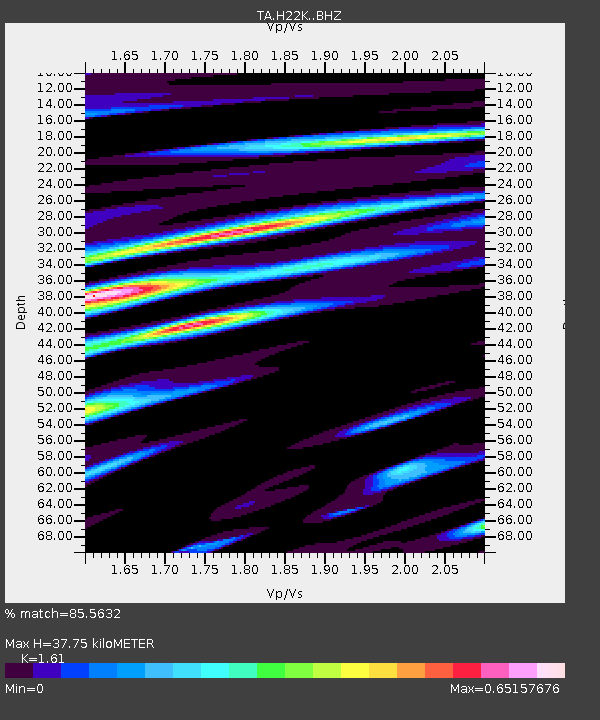
| Estimated Moho Depth: |
37.75 km |
| Estimated Crust Vp/Vs: |
1.61 |
| Assumed Crust Vp: |
6.566 km/s |
| Estimated Crust Vs: |
4.078 km/s |
| Estimated Crust Poisson's Ratio: |
0.19 |
|
| Radial Match: |
85.5632 % |
| Radial Bump: |
400 |
| Transverse Match: |
78.21096 % |
| Transverse Bump: |
400 |
| SOD ConfigId: |
13570011 |
| Insert Time: |
2019-04-28 21:19:51.277 +0000 |
| GWidth: |
2.5 |
| Max Bumps: |
400 |
| Tol: |
0.001 |
|

Signal To Noise
| Channel | StoN | STA | LTA |
| TA:H22K: :BHZ:20170925T20:41:15.300007Z | 12.422035 | 8.312269E-7 | 6.691552E-8 |
| TA:H22K: :BHN:20170925T20:41:15.300007Z | 2.7285354 | 1.554532E-7 | 5.6973132E-8 |
| TA:H22K: :BHE:20170925T20:41:15.300007Z | 3.0209165 | 2.2626033E-7 | 7.489791E-8 |
| Arrivals |
| Ps | 3.6 SECOND |
| PpPs | 15 SECOND |
| PsPs/PpSs | 18 SECOND |


