You are here: Home > Network List > TA - USArray Transportable Network (new EarthScope stations) Stations List
> Station J20K Nowitna River, AK, USA > Earthquake Result Viewer
J20K Nowitna River, AK, USA - Earthquake Result Viewer
| Earthquake location: |
New Britain Region, P.N.G. |
| Earthquake latitude/longitude: |
-6.2/152.7 |
| Earthquake time(UTC): |
2017/09/25 (268) 20:29:23 GMT |
| Earthquake Depth: |
6.0 km |
| Earthquake Magnitude: |
5.9 Mww |
| Earthquake Catalog/Contributor: |
NEIC PDE/us |
|
| Network: |
TA USArray Transportable Network (new EarthScope stations) |
| Station: |
J20K Nowitna River, AK, USA |
| Lat/Lon: |
64.18 N/154.15 W |
| Elevation: |
314 m |
|
| Distance: |
80.5 deg |
| Az: |
20.81 deg |
| Baz: |
233.752 deg |
| Ray Param: |
0.048222523 |
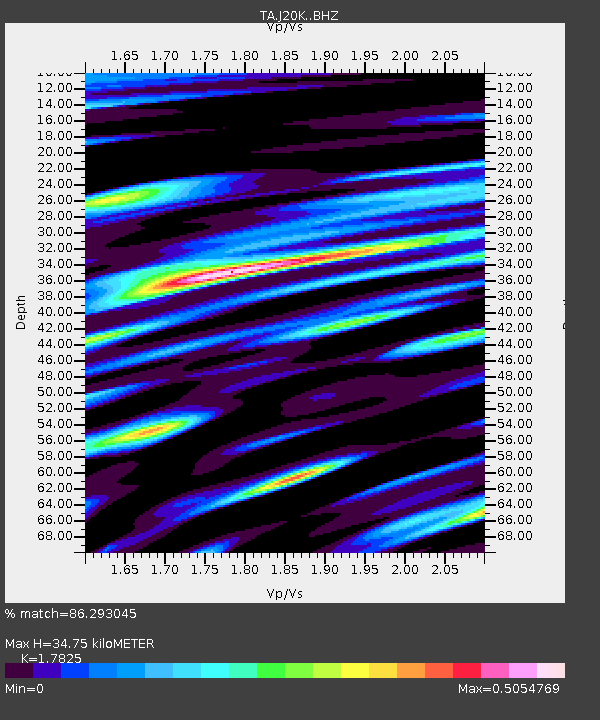
| Estimated Moho Depth: |
34.75 km |
| Estimated Crust Vp/Vs: |
1.78 |
| Assumed Crust Vp: |
6.566 km/s |
| Estimated Crust Vs: |
3.684 km/s |
| Estimated Crust Poisson's Ratio: |
0.27 |
|
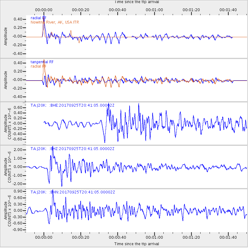
| Radial Match: |
86.293045 % |
| Radial Bump: |
400 |
| Transverse Match: |
70.80875 % |
| Transverse Bump: |
400 |
| SOD ConfigId: |
13570011 |
| Insert Time: |
2019-04-28 21:20:08.875 +0000 |
| GWidth: |
2.5 |
| Max Bumps: |
400 |
| Tol: |
0.001 |
|
Signal To Noise
| Channel | StoN | STA | LTA |
| TA:J20K: :BHZ:20170925T20:41:05.00002Z | 11.5671015 | 9.010811E-7 | 7.790033E-8 |
| TA:J20K: :BHN:20170925T20:41:05.00002Z | 3.153286 | 2.9956917E-7 | 9.500222E-8 |
| TA:J20K: :BHE:20170925T20:41:05.00002Z | 3.7321067 | 2.9849886E-7 | 7.9981334E-8 |
| Arrivals |
| Ps | 4.3 SECOND |
| PpPs | 14 SECOND |
| PsPs/PpSs | 19 SECOND |


