You are here: Home > Network List > TA - USArray Transportable Network (new EarthScope stations) Stations List
> Station M16K Timber Creek, AK, USA > Earthquake Result Viewer
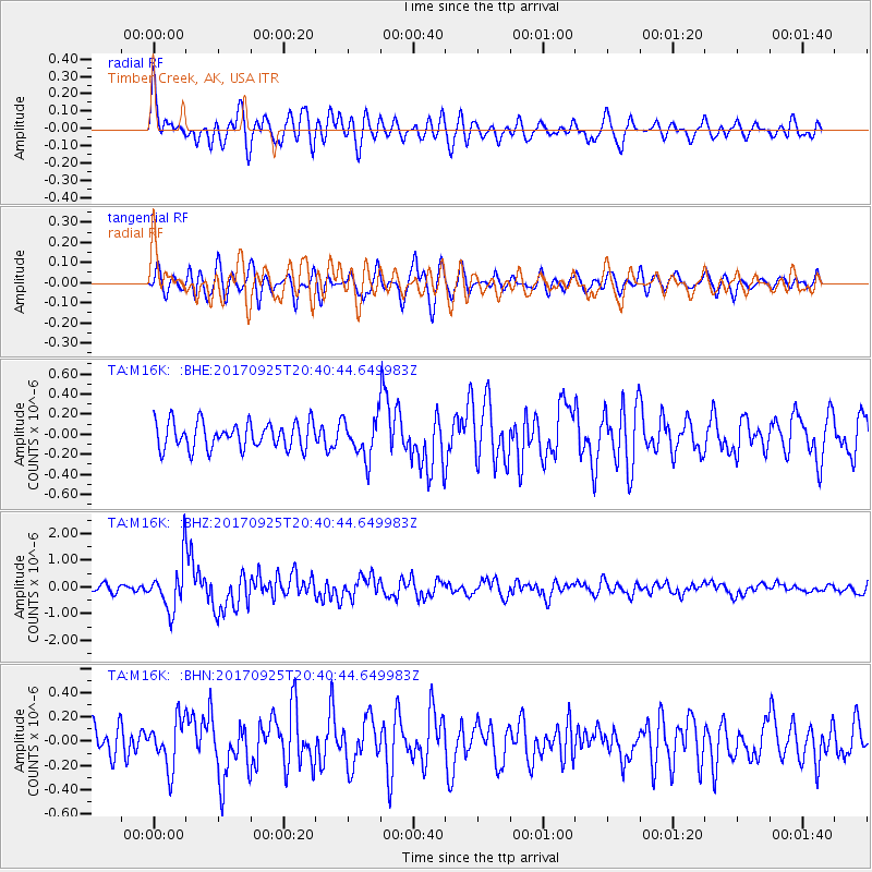
M16K Timber Creek, AK, USA - Earthquake Result Viewer
*The percent match for this event was below the threshold and hence no stack was calculated.
| Earthquake location: |
New Britain Region, P.N.G. |
| Earthquake latitude/longitude: |
-6.2/152.7 |
| Earthquake time(UTC): |
2017/09/25 (268) 20:29:23 GMT |
| Earthquake Depth: |
6.0 km |
| Earthquake Magnitude: |
5.9 Mww |
| Earthquake Catalog/Contributor: |
NEIC PDE/us |
|
| Network: |
TA USArray Transportable Network (new EarthScope stations) |
| Station: |
M16K Timber Creek, AK, USA |
| Lat/Lon: |
61.02 N/158.96 W |
| Elevation: |
394 m |
|
| Distance: |
76.8 deg |
| Az: |
21.937 deg |
| Baz: |
229.705 deg |
| Ray Param: |
$rayparam |
*The percent match for this event was below the threshold and hence was not used in the summary stack. |
|
| Radial Match: |
78.78306 % |
| Radial Bump: |
400 |
| Transverse Match: |
64.70011 % |
| Transverse Bump: |
400 |
| SOD ConfigId: |
13570011 |
| Insert Time: |
2019-04-28 21:20:28.432 +0000 |
| GWidth: |
2.5 |
| Max Bumps: |
400 |
| Tol: |
0.001 |
|
Signal To Noise
| Channel | StoN | STA | LTA |
| TA:M16K: :BHZ:20170925T20:40:44.649983Z | 5.5452228 | 8.8009403E-7 | 1.5871211E-7 |
| TA:M16K: :BHN:20170925T20:40:44.649983Z | 1.4288191 | 1.9566367E-7 | 1.3694083E-7 |
| TA:M16K: :BHE:20170925T20:40:44.649983Z | 1.4818994 | 1.9517128E-7 | 1.3170347E-7 |
| Arrivals |
| Ps | |
| PpPs | |
| PsPs/PpSs | |


