You are here: Home > Network List > TA - USArray Transportable Network (new EarthScope stations) Stations List
> Station U25A Circle Dot Ranch, Maxwell, NM, USA > Earthquake Result Viewer
U25A Circle Dot Ranch, Maxwell, NM, USA - Earthquake Result Viewer
| Earthquake location: |
Southern Peru |
| Earthquake latitude/longitude: |
-16.0/-71.7 |
| Earthquake time(UTC): |
2008/07/08 (190) 09:13:07 GMT |
| Earthquake Depth: |
123 km |
| Earthquake Magnitude: |
5.8 MB, 6.2 MW, 6.2 MW |
| Earthquake Catalog/Contributor: |
WHDF/NEIC |
|
| Network: |
TA USArray Transportable Network (new EarthScope stations) |
| Station: |
U25A Circle Dot Ranch, Maxwell, NM, USA |
| Lat/Lon: |
36.40 N/104.41 W |
| Elevation: |
1845 m |
|
| Distance: |
60.6 deg |
| Az: |
330.002 deg |
| Baz: |
143.413 deg |
| Ray Param: |
0.06108927 |
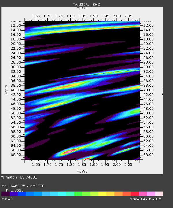
| Estimated Moho Depth: |
69.75 km |
| Estimated Crust Vp/Vs: |
1.86 |
| Assumed Crust Vp: |
6.316 km/s |
| Estimated Crust Vs: |
3.391 km/s |
| Estimated Crust Poisson's Ratio: |
0.30 |
|
| Radial Match: |
83.74031 % |
| Radial Bump: |
373 |
| Transverse Match: |
66.67509 % |
| Transverse Bump: |
400 |
| SOD ConfigId: |
2504 |
| Insert Time: |
2010-03-06 04:18:04.462 +0000 |
| GWidth: |
2.5 |
| Max Bumps: |
400 |
| Tol: |
0.001 |
|

Signal To Noise
| Channel | StoN | STA | LTA |
| TA:U25A: :BHZ:20080708T09:22:34.175027Z | 6.8166456 | 5.3551366E-7 | 7.85597E-8 |
| TA:U25A: :BHN:20080708T09:22:34.175027Z | 4.86116 | 3.130942E-7 | 6.44073E-8 |
| TA:U25A: :BHE:20080708T09:22:34.175027Z | 2.551014 | 1.8032283E-7 | 7.068673E-8 |
| Arrivals |
| Ps | 9.9 SECOND |
| PpPs | 30 SECOND |
| PsPs/PpSs | 40 SECOND |


