You are here: Home > Network List > TA - USArray Transportable Network (new EarthScope stations) Stations List
> Station M31M Drury Creek, Yukon, CA > Earthquake Result Viewer
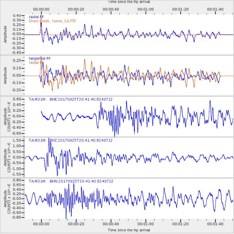
M31M Drury Creek, Yukon, CA - Earthquake Result Viewer
*The percent match for this event was below the threshold and hence no stack was calculated.
| Earthquake location: |
New Britain Region, P.N.G. |
| Earthquake latitude/longitude: |
-6.2/152.7 |
| Earthquake time(UTC): |
2017/09/25 (268) 20:29:23 GMT |
| Earthquake Depth: |
6.0 km |
| Earthquake Magnitude: |
5.9 Mww |
| Earthquake Catalog/Contributor: |
NEIC PDE/us |
|
| Network: |
TA USArray Transportable Network (new EarthScope stations) |
| Station: |
M31M Drury Creek, Yukon, CA |
| Lat/Lon: |
62.20 N/134.39 W |
| Elevation: |
639 m |
|
| Distance: |
87.6 deg |
| Az: |
26.645 deg |
| Baz: |
252.005 deg |
| Ray Param: |
$rayparam |
*The percent match for this event was below the threshold and hence was not used in the summary stack. |
|
| Radial Match: |
66.69742 % |
| Radial Bump: |
400 |
| Transverse Match: |
64.96888 % |
| Transverse Bump: |
400 |
| SOD ConfigId: |
13570011 |
| Insert Time: |
2019-04-28 21:20:37.229 +0000 |
| GWidth: |
2.5 |
| Max Bumps: |
400 |
| Tol: |
0.001 |
|
Signal To Noise
| Channel | StoN | STA | LTA |
| TA:M31M: :BHZ:20170925T20:41:40.824971Z | 5.081243 | 6.3177873E-7 | 1.2433547E-7 |
| TA:M31M: :BHN:20170925T20:41:40.824971Z | 0.8991832 | 1.2322755E-7 | 1.3704388E-7 |
| TA:M31M: :BHE:20170925T20:41:40.824971Z | 2.564004 | 2.0338338E-7 | 7.932257E-8 |
| Arrivals |
| Ps | |
| PpPs | |
| PsPs/PpSs | |


