You are here: Home > Network List > TA - USArray Transportable Network (new EarthScope stations) Stations List
> Station U25A Circle Dot Ranch, Maxwell, NM, USA > Earthquake Result Viewer
U25A Circle Dot Ranch, Maxwell, NM, USA - Earthquake Result Viewer
| Earthquake location: |
Off East Coast Of Honshu, Japan |
| Earthquake latitude/longitude: |
37.6/142.2 |
| Earthquake time(UTC): |
2008/07/19 (201) 02:39:28 GMT |
| Earthquake Depth: |
22 km |
| Earthquake Magnitude: |
6.2 MB, 7.0 MS, 7.0 MW, 6.9 MW |
| Earthquake Catalog/Contributor: |
WHDF/NEIC |
|
| Network: |
TA USArray Transportable Network (new EarthScope stations) |
| Station: |
U25A Circle Dot Ranch, Maxwell, NM, USA |
| Lat/Lon: |
36.40 N/104.41 W |
| Elevation: |
1845 m |
|
| Distance: |
84.0 deg |
| Az: |
48.126 deg |
| Baz: |
312.818 deg |
| Ray Param: |
0.04575189 |
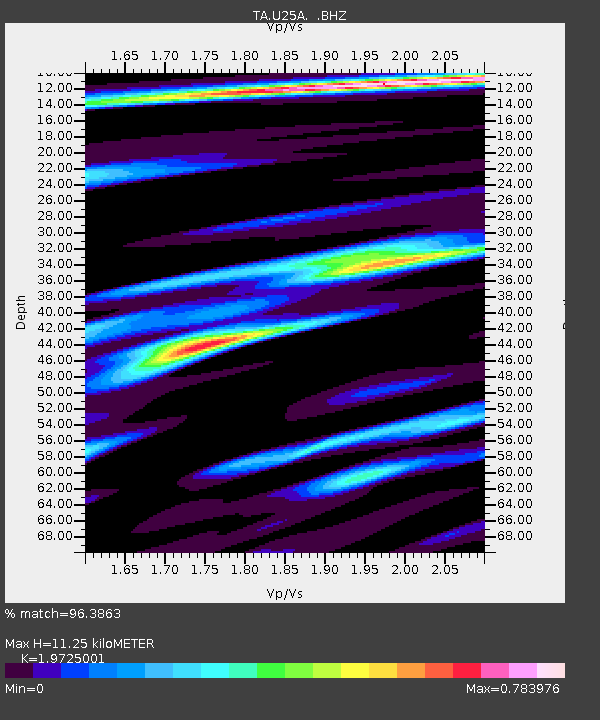
| Estimated Moho Depth: |
11.25 km |
| Estimated Crust Vp/Vs: |
1.97 |
| Assumed Crust Vp: |
6.316 km/s |
| Estimated Crust Vs: |
3.202 km/s |
| Estimated Crust Poisson's Ratio: |
0.33 |
|
| Radial Match: |
96.3863 % |
| Radial Bump: |
400 |
| Transverse Match: |
84.73861 % |
| Transverse Bump: |
400 |
| SOD ConfigId: |
2504 |
| Insert Time: |
2010-03-06 04:18:06.779 +0000 |
| GWidth: |
2.5 |
| Max Bumps: |
400 |
| Tol: |
0.001 |
|

Signal To Noise
| Channel | StoN | STA | LTA |
| TA:U25A: :BHZ:20080719T02:51:25.950Z | 6.06016 | 5.1981954E-7 | 8.5776534E-8 |
| TA:U25A: :BHN:20080719T02:51:25.950Z | 2.1039958 | 1.4858854E-7 | 7.062207E-8 |
| TA:U25A: :BHE:20080719T02:51:25.950Z | 3.7884352 | 1.368939E-7 | 3.6134683E-8 |
| Arrivals |
| Ps | 1.8 SECOND |
| PpPs | 5.2 SECOND |
| PsPs/PpSs | 7.0 SECOND |


