You are here: Home > Network List > TA - USArray Transportable Network (new EarthScope stations) Stations List
> Station U25A Circle Dot Ranch, Maxwell, NM, USA > Earthquake Result Viewer
U25A Circle Dot Ranch, Maxwell, NM, USA - Earthquake Result Viewer

| Earthquake location: |
Eastern Honshu, Japan |
| Earthquake latitude/longitude: |
39.8/141.5 |
| Earthquake time(UTC): |
2008/07/23 (205) 15:26:19 GMT |
| Earthquake Depth: |
108 km |
| Earthquake Magnitude: |
6.6 MB, 6.8 MW, 6.8 MW |
| Earthquake Catalog/Contributor: |
WHDF/NEIC |
|
| Network: |
TA USArray Transportable Network (new EarthScope stations) |
| Station: |
U25A Circle Dot Ranch, Maxwell, NM, USA |
| Lat/Lon: |
36.40 N/104.41 W |
| Elevation: |
1845 m |
|
| Distance: |
83.0 deg |
| Az: |
47.894 deg |
| Baz: |
314.894 deg |
| Ray Param: |
0.046291657 |
| Estimated Moho Depth: |
10.5 km |
| Estimated Crust Vp/Vs: |
2.10 |
| Assumed Crust Vp: |
6.316 km/s |
| Estimated Crust Vs: |
3.011 km/s |
| Estimated Crust Poisson's Ratio: |
0.35 |
|
| Radial Match: |
96.74728 % |
| Radial Bump: |
400 |
| Transverse Match: |
89.9881 % |
| Transverse Bump: |
400 |
| SOD ConfigId: |
2504 |
| Insert Time: |
2010-03-06 04:18:08.890 +0000 |
| GWidth: |
2.5 |
| Max Bumps: |
400 |
| Tol: |
0.001 |
|
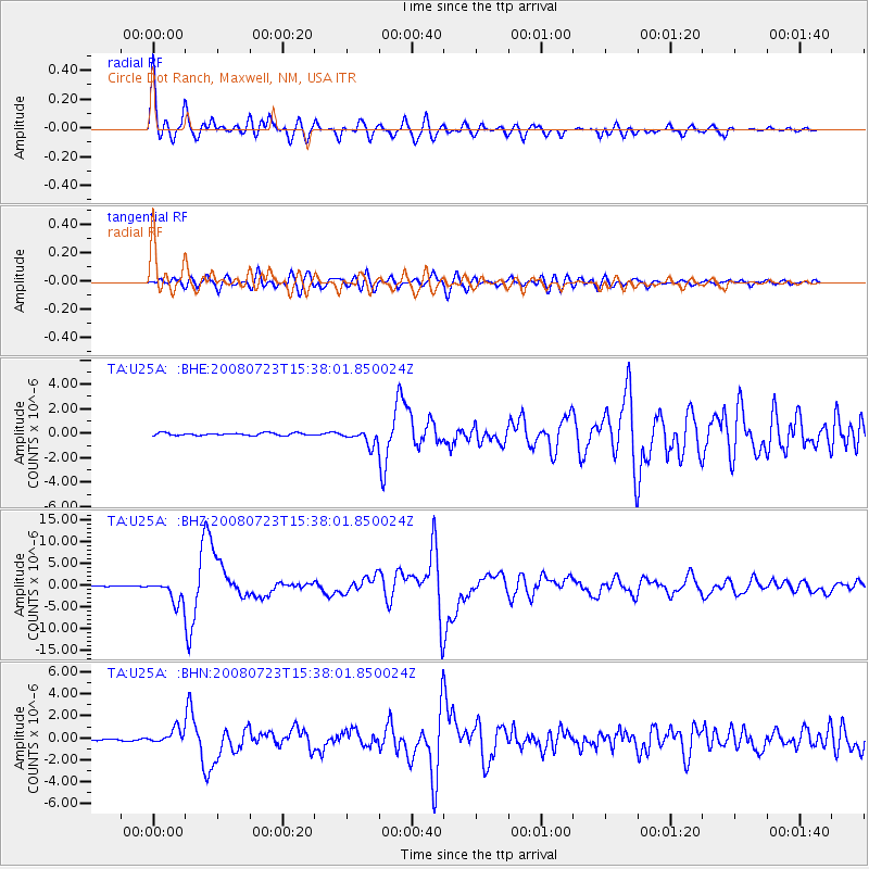
Signal To Noise
| Channel | StoN | STA | LTA |
| TA:U25A: :BHZ:20080723T15:38:01.850024Z | 18.661242 | 2.5862062E-6 | 1.3858703E-7 |
| TA:U25A: :BHN:20080723T15:38:01.850024Z | 5.216758 | 6.5917425E-7 | 1.2635708E-7 |
| TA:U25A: :BHE:20080723T15:38:01.850024Z | 6.071882 | 6.077589E-7 | 1.0009399E-7 |
| Arrivals |
| Ps | 1.9 SECOND |
| PpPs | 5.0 SECOND |
| PsPs/PpSs | 6.9 SECOND |


