You are here: Home > Network List > TA - USArray Transportable Network (new EarthScope stations) Stations List
> Station O28M Mount Upton, YT, CAN > Earthquake Result Viewer
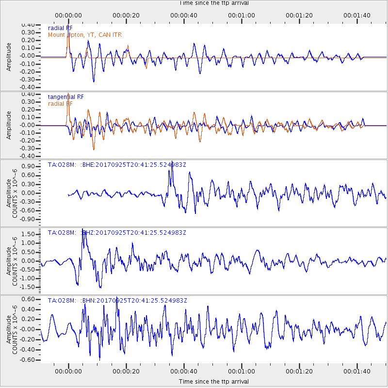
O28M Mount Upton, YT, CAN - Earthquake Result Viewer

| Earthquake location: |
New Britain Region, P.N.G. |
| Earthquake latitude/longitude: |
-6.2/152.7 |
| Earthquake time(UTC): |
2017/09/25 (268) 20:29:23 GMT |
| Earthquake Depth: |
6.0 km |
| Earthquake Magnitude: |
5.9 Mww |
| Earthquake Catalog/Contributor: |
NEIC PDE/us |
|
| Network: |
TA USArray Transportable Network (new EarthScope stations) |
| Station: |
O28M Mount Upton, YT, CAN |
| Lat/Lon: |
60.77 N/140.19 W |
| Elevation: |
2622 m |
|
| Distance: |
84.5 deg |
| Az: |
27.014 deg |
| Baz: |
246.94 deg |
| Ray Param: |
0.045462776 |
| Estimated Moho Depth: |
44.75 km |
| Estimated Crust Vp/Vs: |
1.98 |
| Assumed Crust Vp: |
6.566 km/s |
| Estimated Crust Vs: |
3.312 km/s |
| Estimated Crust Poisson's Ratio: |
0.33 |
|
| Radial Match: |
80.97771 % |
| Radial Bump: |
400 |
| Transverse Match: |
60.074013 % |
| Transverse Bump: |
400 |
| SOD ConfigId: |
13570011 |
| Insert Time: |
2019-04-28 21:20:52.817 +0000 |
| GWidth: |
2.5 |
| Max Bumps: |
400 |
| Tol: |
0.001 |
|
Signal To Noise
| Channel | StoN | STA | LTA |
| TA:O28M: :BHZ:20170925T20:41:25.524983Z | 7.0942025 | 6.40553E-7 | 9.029246E-8 |
| TA:O28M: :BHN:20170925T20:41:25.524983Z | 1.2735696 | 1.4265595E-7 | 1.1201269E-7 |
| TA:O28M: :BHE:20170925T20:41:25.524983Z | 3.132746 | 2.0460355E-7 | 6.531125E-8 |
| Arrivals |
| Ps | 6.9 SECOND |
| PpPs | 20 SECOND |
| PsPs/PpSs | 27 SECOND |


