You are here: Home > Network List > TA - USArray Transportable Network (new EarthScope stations) Stations List
> Station Q20K Shuyak Island, AK, USA > Earthquake Result Viewer
Q20K Shuyak Island, AK, USA - Earthquake Result Viewer
| Earthquake location: |
New Britain Region, P.N.G. |
| Earthquake latitude/longitude: |
-6.2/152.7 |
| Earthquake time(UTC): |
2017/09/25 (268) 20:29:23 GMT |
| Earthquake Depth: |
6.0 km |
| Earthquake Magnitude: |
5.9 Mww |
| Earthquake Catalog/Contributor: |
NEIC PDE/us |
|
| Network: |
TA USArray Transportable Network (new EarthScope stations) |
| Station: |
Q20K Shuyak Island, AK, USA |
| Lat/Lon: |
58.61 N/152.39 W |
| Elevation: |
180 m |
|
| Distance: |
78.0 deg |
| Az: |
25.96 deg |
| Baz: |
236.25 deg |
| Ray Param: |
0.049938824 |
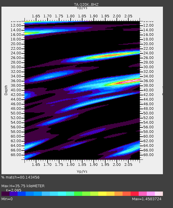
| Estimated Moho Depth: |
35.75 km |
| Estimated Crust Vp/Vs: |
2.07 |
| Assumed Crust Vp: |
5.989 km/s |
| Estimated Crust Vs: |
2.9 km/s |
| Estimated Crust Poisson's Ratio: |
0.35 |
|
| Radial Match: |
80.143456 % |
| Radial Bump: |
400 |
| Transverse Match: |
71.28006 % |
| Transverse Bump: |
400 |
| SOD ConfigId: |
13570011 |
| Insert Time: |
2019-04-28 21:21:05.205 +0000 |
| GWidth: |
2.5 |
| Max Bumps: |
400 |
| Tol: |
0.001 |
|

Signal To Noise
| Channel | StoN | STA | LTA |
| TA:Q20K: :BHZ:20170925T20:40:51.324971Z | 9.502952 | 1.2113162E-6 | 1.2746736E-7 |
| TA:Q20K: :BHN:20170925T20:40:51.324971Z | 1.580376 | 2.1121305E-7 | 1.3364733E-7 |
| TA:Q20K: :BHE:20170925T20:40:51.324971Z | 3.0903497 | 4.6847677E-7 | 1.5159344E-7 |
| Arrivals |
| Ps | 6.5 SECOND |
| PpPs | 18 SECOND |
| PsPs/PpSs | 24 SECOND |


