You are here: Home > Network List > TA - USArray Transportable Network (new EarthScope stations) Stations List
> Station U25A Circle Dot Ranch, Maxwell, NM, USA > Earthquake Result Viewer
U25A Circle Dot Ranch, Maxwell, NM, USA - Earthquake Result Viewer

| Earthquake location: |
Vanuatu Islands |
| Earthquake latitude/longitude: |
-13.5/167.0 |
| Earthquake time(UTC): |
2008/09/08 (252) 18:52:06 GMT |
| Earthquake Depth: |
110 km |
| Earthquake Magnitude: |
6.4 MB, 6.9 MW, 6.9 MW |
| Earthquake Catalog/Contributor: |
WHDF/NEIC |
|
| Network: |
TA USArray Transportable Network (new EarthScope stations) |
| Station: |
U25A Circle Dot Ranch, Maxwell, NM, USA |
| Lat/Lon: |
36.40 N/104.41 W |
| Elevation: |
1845 m |
|
| Distance: |
96.8 deg |
| Az: |
54.317 deg |
| Baz: |
258.324 deg |
| Ray Param: |
0.040320497 |
| Estimated Moho Depth: |
45.0 km |
| Estimated Crust Vp/Vs: |
1.62 |
| Assumed Crust Vp: |
6.316 km/s |
| Estimated Crust Vs: |
3.905 km/s |
| Estimated Crust Poisson's Ratio: |
0.19 |
|
| Radial Match: |
93.680244 % |
| Radial Bump: |
306 |
| Transverse Match: |
73.08831 % |
| Transverse Bump: |
400 |
| SOD ConfigId: |
2560 |
| Insert Time: |
2010-03-06 04:18:21.765 +0000 |
| GWidth: |
2.5 |
| Max Bumps: |
400 |
| Tol: |
0.001 |
|
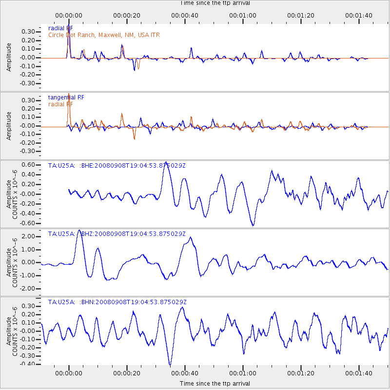
Signal To Noise
| Channel | StoN | STA | LTA |
| TA:U25A: :BHZ:20080908T19:04:53.875029Z | 17.222498 | 1.4552882E-6 | 8.449925E-8 |
| TA:U25A: :BHN:20080908T19:04:53.875029Z | 0.9121461 | 1.09717185E-7 | 1.2028465E-7 |
| TA:U25A: :BHE:20080908T19:04:53.875029Z | 5.9523115 | 3.9290634E-7 | 6.600904E-8 |
| Arrivals |
| Ps | 4.5 SECOND |
| PpPs | 18 SECOND |
| PsPs/PpSs | 23 SECOND |


