You are here: Home > Network List > G - GEOSCOPE Stations List
> Station IVI Ivittuut, Greenland > Earthquake Result Viewer
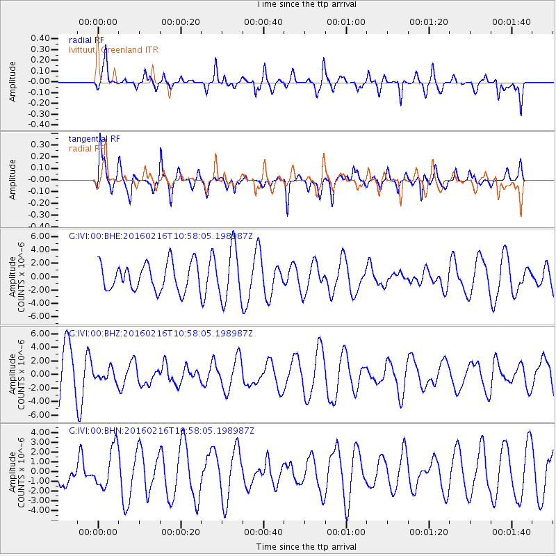
IVI Ivittuut, Greenland - Earthquake Result Viewer
*The percent match for this event was below the threshold and hence no stack was calculated.
| Earthquake location: |
Near Coast Of Peru |
| Earthquake latitude/longitude: |
-16.4/-73.5 |
| Earthquake time(UTC): |
2016/02/16 (047) 10:46:27 GMT |
| Earthquake Depth: |
13 km |
| Earthquake Magnitude: |
5.7 MWW, 5.6 MWB, 5.7 MWC |
| Earthquake Catalog/Contributor: |
NEIC PDE/NEIC COMCAT |
|
| Network: |
G GEOSCOPE |
| Station: |
IVI Ivittuut, Greenland |
| Lat/Lon: |
61.21 N/48.17 W |
| Elevation: |
15 m |
|
| Distance: |
80.0 deg |
| Az: |
12.161 deg |
| Baz: |
204.682 deg |
| Ray Param: |
$rayparam |
*The percent match for this event was below the threshold and hence was not used in the summary stack. |
|
| Radial Match: |
61.227516 % |
| Radial Bump: |
400 |
| Transverse Match: |
56.608517 % |
| Transverse Bump: |
400 |
| SOD ConfigId: |
1453031 |
| Insert Time: |
2016-03-24 11:36:56.119 +0000 |
| GWidth: |
2.5 |
| Max Bumps: |
400 |
| Tol: |
0.001 |
|
Signal To Noise
| Channel | StoN | STA | LTA |
| G:IVI:00:BHZ:20160216T10:58:05.198987Z | 0.21914166 | 8.813531E-7 | 4.021842E-6 |
| G:IVI:00:BHN:20160216T10:58:05.198987Z | 1.6498333 | 2.159823E-6 | 1.3091158E-6 |
| G:IVI:00:BHE:20160216T10:58:05.198987Z | 1.9706249 | 4.0124028E-6 | 2.036107E-6 |
| Arrivals |
| Ps | |
| PpPs | |
| PsPs/PpSs | |


