You are here: Home > Network List > AE - Arizona Broadband Seismic Network Stations List
> Station X16A Lo Mia Camp, Pine, AZ, USA > Earthquake Result Viewer
X16A Lo Mia Camp, Pine, AZ, USA - Earthquake Result Viewer
| Earthquake location: |
South Of Fiji Islands |
| Earthquake latitude/longitude: |
-23.7/-176.9 |
| Earthquake time(UTC): |
2017/09/26 (269) 04:20:00 GMT |
| Earthquake Depth: |
98 km |
| Earthquake Magnitude: |
6.4 mww |
| Earthquake Catalog/Contributor: |
NEIC PDE/us |
|
| Network: |
AE Arizona Broadband Seismic Network |
| Station: |
X16A Lo Mia Camp, Pine, AZ, USA |
| Lat/Lon: |
34.42 N/111.44 W |
| Elevation: |
1759 m |
|
| Distance: |
84.9 deg |
| Az: |
49.048 deg |
| Baz: |
236.861 deg |
| Ray Param: |
0.04495747 |
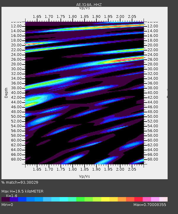
| Estimated Moho Depth: |
19.5 km |
| Estimated Crust Vp/Vs: |
1.60 |
| Assumed Crust Vp: |
6.207 km/s |
| Estimated Crust Vs: |
3.879 km/s |
| Estimated Crust Poisson's Ratio: |
0.18 |
|
| Radial Match: |
93.38029 % |
| Radial Bump: |
400 |
| Transverse Match: |
87.398575 % |
| Transverse Bump: |
400 |
| SOD ConfigId: |
13570011 |
| Insert Time: |
2019-04-28 21:22:48.008 +0000 |
| GWidth: |
2.5 |
| Max Bumps: |
400 |
| Tol: |
0.001 |
|

Signal To Noise
| Channel | StoN | STA | LTA |
| AE:X16A: :HHZ:20170926T04:31:53.52001Z | 15.580911 | 1.7843347E-6 | 1.1452057E-7 |
| AE:X16A: :HHN:20170926T04:31:53.52001Z | 2.3852715 | 2.3009787E-7 | 9.64661E-8 |
| AE:X16A: :HHE:20170926T04:31:53.52001Z | 6.4299107 | 6.2216634E-7 | 9.6761276E-8 |
| Arrivals |
| Ps | 1.9 SECOND |
| PpPs | 8.0 SECOND |
| PsPs/PpSs | 9.9 SECOND |


