You are here: Home > Network List > GS - US Geological Survey Networks Stations List
> Station KAN08 Pence Farm, Harper, KS, USA > Earthquake Result Viewer
KAN08 Pence Farm, Harper, KS, USA - Earthquake Result Viewer
*The percent match for this event was below the threshold and hence no stack was calculated.
| Earthquake location: |
Near Coast Of Peru |
| Earthquake latitude/longitude: |
-16.4/-73.5 |
| Earthquake time(UTC): |
2016/02/16 (047) 10:46:27 GMT |
| Earthquake Depth: |
13 km |
| Earthquake Magnitude: |
5.7 MWW, 5.6 MWB, 5.7 MWC |
| Earthquake Catalog/Contributor: |
NEIC PDE/NEIC COMCAT |
|
| Network: |
GS US Geological Survey Networks |
| Station: |
KAN08 Pence Farm, Harper, KS, USA |
| Lat/Lon: |
37.23 N/97.97 W |
| Elevation: |
375 m |
|
| Distance: |
58.1 deg |
| Az: |
337.124 deg |
| Baz: |
152.134 deg |
| Ray Param: |
$rayparam |
*The percent match for this event was below the threshold and hence was not used in the summary stack. |
|
| Radial Match: |
61.988224 % |
| Radial Bump: |
400 |
| Transverse Match: |
49.237892 % |
| Transverse Bump: |
400 |
| SOD ConfigId: |
1453031 |
| Insert Time: |
2016-03-24 11:37:49.249 +0000 |
| GWidth: |
2.5 |
| Max Bumps: |
400 |
| Tol: |
0.001 |
|
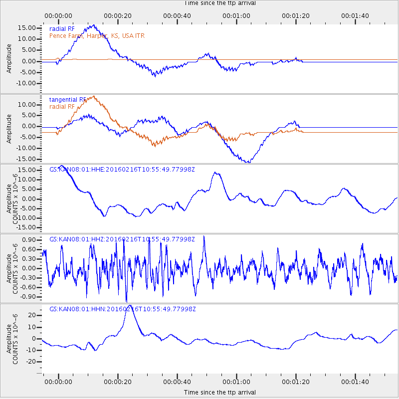
Signal To Noise
| Channel | StoN | STA | LTA |
| GS:KAN08:01:HHZ:20160216T10:55:49.77998Z | 0.9848336 | 2.8521302E-7 | 2.896053E-7 |
| GS:KAN08:01:HHN:20160216T10:55:49.77998Z | 0.49412245 | 2.4005567E-6 | 4.8582224E-6 |
| GS:KAN08:01:HHE:20160216T10:55:49.77998Z | 0.84284526 | 6.8158784E-6 | 8.086749E-6 |
| Arrivals |
| Ps | |
| PpPs | |
| PsPs/PpSs | |


