You are here: Home > Network List > TA - USArray Transportable Network (new EarthScope stations) Stations List
> Station U25A Circle Dot Ranch, Maxwell, NM, USA > Earthquake Result Viewer
U25A Circle Dot Ranch, Maxwell, NM, USA - Earthquake Result Viewer
| Earthquake location: |
Southeast Of Honshu, Japan |
| Earthquake latitude/longitude: |
32.8/140.4 |
| Earthquake time(UTC): |
2009/08/12 (224) 22:48:51 GMT |
| Earthquake Depth: |
53 km |
| Earthquake Magnitude: |
6.2 MB, 6.6 MW, 6.6 MW |
| Earthquake Catalog/Contributor: |
WHDF/NEIC |
|
| Network: |
TA USArray Transportable Network (new EarthScope stations) |
| Station: |
U25A Circle Dot Ranch, Maxwell, NM, USA |
| Lat/Lon: |
36.40 N/104.41 W |
| Elevation: |
1845 m |
|
| Distance: |
88.3 deg |
| Az: |
46.915 deg |
| Baz: |
310.338 deg |
| Ray Param: |
0.042591676 |
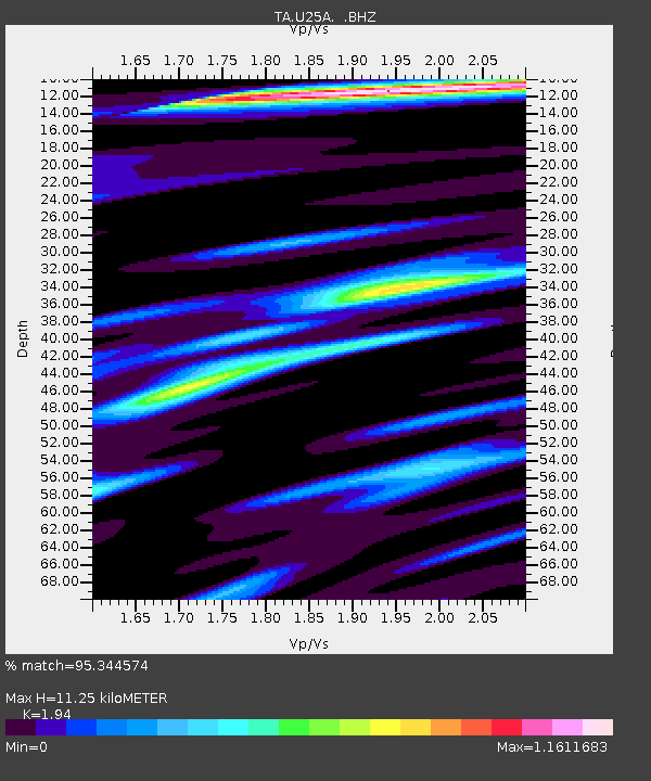
| Estimated Moho Depth: |
11.25 km |
| Estimated Crust Vp/Vs: |
1.94 |
| Assumed Crust Vp: |
6.316 km/s |
| Estimated Crust Vs: |
3.255 km/s |
| Estimated Crust Poisson's Ratio: |
0.32 |
|
| Radial Match: |
95.344574 % |
| Radial Bump: |
400 |
| Transverse Match: |
85.32739 % |
| Transverse Bump: |
400 |
| SOD ConfigId: |
2622 |
| Insert Time: |
2010-03-06 04:18:41.261 +0000 |
| GWidth: |
2.5 |
| Max Bumps: |
400 |
| Tol: |
0.001 |
|

Signal To Noise
| Channel | StoN | STA | LTA |
| TA:U25A: :BHZ:20090812T23:01:06.075029Z | 31.024063 | 1.7440584E-6 | 5.621631E-8 |
| TA:U25A: :BHN:20090812T23:01:06.075029Z | 14.457452 | 3.8174835E-7 | 2.6404955E-8 |
| TA:U25A: :BHE:20090812T23:01:06.075029Z | 13.171291 | 4.5958384E-7 | 3.4892846E-8 |
| Arrivals |
| Ps | 1.7 SECOND |
| PpPs | 5.1 SECOND |
| PsPs/PpSs | 6.8 SECOND |


