You are here: Home > Network List > TA - USArray Transportable Network (new EarthScope stations) Stations List
> Station U25A Circle Dot Ranch, Maxwell, NM, USA > Earthquake Result Viewer
U25A Circle Dot Ranch, Maxwell, NM, USA - Earthquake Result Viewer
| Earthquake location: |
Samoa Islands Region |
| Earthquake latitude/longitude: |
-15.5/-172.1 |
| Earthquake time(UTC): |
2009/09/29 (272) 17:48:10 GMT |
| Earthquake Depth: |
18 km |
| Earthquake Magnitude: |
7.1 MB, 8.1 MS, 8.1 MW, 8.0 MW |
| Earthquake Catalog/Contributor: |
WHDF/NEIC |
|
| Network: |
TA USArray Transportable Network (new EarthScope stations) |
| Station: |
U25A Circle Dot Ranch, Maxwell, NM, USA |
| Lat/Lon: |
36.40 N/104.41 W |
| Elevation: |
1845 m |
|
| Distance: |
82.0 deg |
| Az: |
48.908 deg |
| Baz: |
244.241 deg |
| Ray Param: |
0.047150962 |
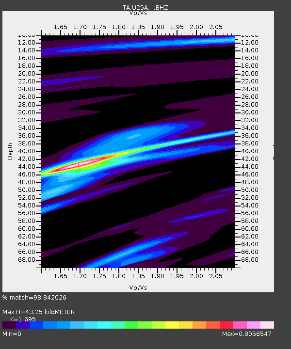
| Estimated Moho Depth: |
43.25 km |
| Estimated Crust Vp/Vs: |
1.70 |
| Assumed Crust Vp: |
6.316 km/s |
| Estimated Crust Vs: |
3.726 km/s |
| Estimated Crust Poisson's Ratio: |
0.23 |
|
| Radial Match: |
98.842026 % |
| Radial Bump: |
230 |
| Transverse Match: |
94.44707 % |
| Transverse Bump: |
400 |
| SOD ConfigId: |
2622 |
| Insert Time: |
2010-03-06 04:18:57.059 +0000 |
| GWidth: |
2.5 |
| Max Bumps: |
400 |
| Tol: |
0.001 |
|

Signal To Noise
| Channel | StoN | STA | LTA |
| TA:U25A: :BHZ:20090929T17:59:58.575022Z | 14.168981 | 2.6899024E-6 | 1.8984446E-7 |
| TA:U25A: :BHN:20090929T17:59:58.575022Z | 3.365565 | 4.462568E-7 | 1.325949E-7 |
| TA:U25A: :BHE:20090929T17:59:58.575022Z | 8.728912 | 7.838497E-7 | 8.9799244E-8 |
| Arrivals |
| Ps | 4.9 SECOND |
| PpPs | 18 SECOND |
| PsPs/PpSs | 23 SECOND |


