You are here: Home > Network List > AK - Alaska Regional Network Stations List
> Station SKN Skwentna > Earthquake Result Viewer
SKN Skwentna - Earthquake Result Viewer
| Earthquake location: |
South Of Fiji Islands |
| Earthquake latitude/longitude: |
-23.7/-176.9 |
| Earthquake time(UTC): |
2017/09/26 (269) 04:20:00 GMT |
| Earthquake Depth: |
98 km |
| Earthquake Magnitude: |
6.4 mww |
| Earthquake Catalog/Contributor: |
NEIC PDE/us |
|
| Network: |
AK Alaska Regional Network |
| Station: |
SKN Skwentna |
| Lat/Lon: |
61.98 N/151.53 W |
| Elevation: |
603 m |
|
| Distance: |
87.8 deg |
| Az: |
11.699 deg |
| Baz: |
203.175 deg |
| Ray Param: |
0.042859014 |
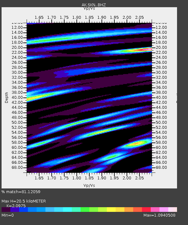
| Estimated Moho Depth: |
20.5 km |
| Estimated Crust Vp/Vs: |
2.10 |
| Assumed Crust Vp: |
6.302 km/s |
| Estimated Crust Vs: |
3.004 km/s |
| Estimated Crust Poisson's Ratio: |
0.35 |
|
| Radial Match: |
81.12059 % |
| Radial Bump: |
400 |
| Transverse Match: |
68.36369 % |
| Transverse Bump: |
400 |
| SOD ConfigId: |
13570011 |
| Insert Time: |
2019-04-28 21:23:48.049 +0000 |
| GWidth: |
2.5 |
| Max Bumps: |
400 |
| Tol: |
0.001 |
|

Signal To Noise
| Channel | StoN | STA | LTA |
| AK:SKN: :BHZ:20170926T04:32:07.747976Z | 28.527256 | 1.659446E-6 | 5.8170542E-8 |
| AK:SKN: :BHN:20170926T04:32:07.747976Z | 6.163499 | 5.7945414E-7 | 9.401383E-8 |
| AK:SKN: :BHE:20170926T04:32:07.747976Z | 4.7931023 | 5.610366E-7 | 1.17050824E-7 |
| Arrivals |
| Ps | 3.6 SECOND |
| PpPs | 9.9 SECOND |
| PsPs/PpSs | 14 SECOND |


