You are here: Home > Network List > AV - Alaska Volcano Observatory Stations List
> Station OKCE Cone E, Okmok Caldera, Alaska > Earthquake Result Viewer
OKCE Cone E, Okmok Caldera, Alaska - Earthquake Result Viewer
| Earthquake location: |
South Of Fiji Islands |
| Earthquake latitude/longitude: |
-23.7/-176.9 |
| Earthquake time(UTC): |
2017/09/26 (269) 04:20:00 GMT |
| Earthquake Depth: |
98 km |
| Earthquake Magnitude: |
6.4 mww |
| Earthquake Catalog/Contributor: |
NEIC PDE/us |
|
| Network: |
AV Alaska Volcano Observatory |
| Station: |
OKCE Cone E, Okmok Caldera, Alaska |
| Lat/Lon: |
53.43 N/168.17 W |
| Elevation: |
515 m |
|
| Distance: |
77.2 deg |
| Az: |
5.369 deg |
| Baz: |
188.24 deg |
| Ray Param: |
0.05026538 |
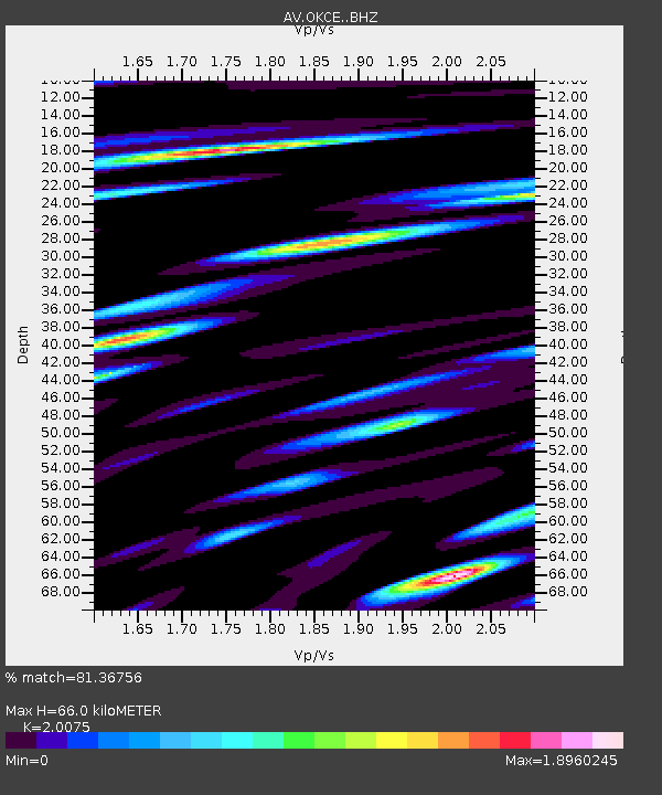
| Estimated Moho Depth: |
66.0 km |
| Estimated Crust Vp/Vs: |
2.01 |
| Assumed Crust Vp: |
5.88 km/s |
| Estimated Crust Vs: |
2.929 km/s |
| Estimated Crust Poisson's Ratio: |
0.33 |
|
| Radial Match: |
81.36756 % |
| Radial Bump: |
400 |
| Transverse Match: |
60.25606 % |
| Transverse Bump: |
400 |
| SOD ConfigId: |
13570011 |
| Insert Time: |
2019-04-28 21:24:51.408 +0000 |
| GWidth: |
2.5 |
| Max Bumps: |
400 |
| Tol: |
0.001 |
|

Signal To Noise
| Channel | StoN | STA | LTA |
| AV:OKCE: :BHZ:20170926T04:31:12.918997Z | 14.95879 | 1.0106129E-5 | 6.75598E-7 |
| AV:OKCE: :BHN:20170926T04:31:12.918997Z | 7.6547008 | 7.444448E-6 | 9.725328E-7 |
| AV:OKCE: :BHE:20170926T04:31:12.918997Z | 4.539232 | 5.684286E-6 | 1.2522573E-6 |
| Arrivals |
| Ps | 12 SECOND |
| PpPs | 33 SECOND |
| PsPs/PpSs | 45 SECOND |


