You are here: Home > Network List > AV - Alaska Volcano Observatory Stations List
> Station OKFG Fort Glenn, Okmok Caldera, Alaska > Earthquake Result Viewer
OKFG Fort Glenn, Okmok Caldera, Alaska - Earthquake Result Viewer
| Earthquake location: |
South Of Fiji Islands |
| Earthquake latitude/longitude: |
-23.7/-176.9 |
| Earthquake time(UTC): |
2017/09/26 (269) 04:20:00 GMT |
| Earthquake Depth: |
98 km |
| Earthquake Magnitude: |
6.4 mww |
| Earthquake Catalog/Contributor: |
NEIC PDE/us |
|
| Network: |
AV Alaska Volcano Observatory |
| Station: |
OKFG Fort Glenn, Okmok Caldera, Alaska |
| Lat/Lon: |
53.41 N/167.91 W |
| Elevation: |
201 m |
|
| Distance: |
77.2 deg |
| Az: |
5.526 deg |
| Baz: |
188.479 deg |
| Ray Param: |
0.05026063 |
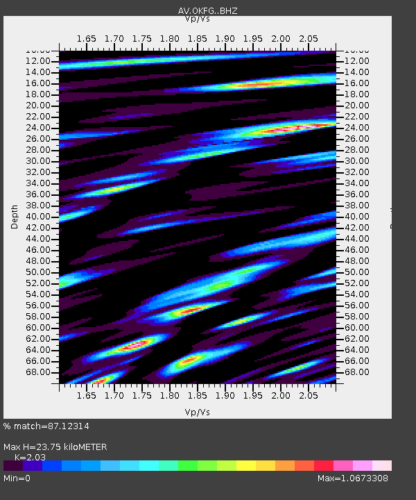
| Estimated Moho Depth: |
23.75 km |
| Estimated Crust Vp/Vs: |
2.03 |
| Assumed Crust Vp: |
3.943 km/s |
| Estimated Crust Vs: |
1.943 km/s |
| Estimated Crust Poisson's Ratio: |
0.34 |
|
| Radial Match: |
87.12314 % |
| Radial Bump: |
400 |
| Transverse Match: |
84.73547 % |
| Transverse Bump: |
400 |
| SOD ConfigId: |
13570011 |
| Insert Time: |
2019-04-28 21:24:51.424 +0000 |
| GWidth: |
2.5 |
| Max Bumps: |
400 |
| Tol: |
0.001 |
|

Signal To Noise
| Channel | StoN | STA | LTA |
| AV:OKFG: :BHZ:20170926T04:31:12.958975Z | 25.194168 | 1.16572955E-5 | 4.6269815E-7 |
| AV:OKFG: :BHN:20170926T04:31:12.958975Z | 5.3545656 | 3.865404E-6 | 7.2188936E-7 |
| AV:OKFG: :BHE:20170926T04:31:12.958975Z | 3.2933855 | 2.4114318E-6 | 7.3220457E-7 |
| Arrivals |
| Ps | 6.3 SECOND |
| PpPs | 18 SECOND |
| PsPs/PpSs | 24 SECOND |


