You are here: Home > Network List > AV - Alaska Volcano Observatory Stations List
> Station WACK Chichokna Glacier, Wrangell, Alaska > Earthquake Result Viewer
WACK Chichokna Glacier, Wrangell, Alaska - Earthquake Result Viewer
| Earthquake location: |
South Of Fiji Islands |
| Earthquake latitude/longitude: |
-23.7/-176.9 |
| Earthquake time(UTC): |
2017/09/26 (269) 04:20:00 GMT |
| Earthquake Depth: |
98 km |
| Earthquake Magnitude: |
6.4 mww |
| Earthquake Catalog/Contributor: |
NEIC PDE/us |
|
| Network: |
AV Alaska Volcano Observatory |
| Station: |
WACK Chichokna Glacier, Wrangell, Alaska |
| Lat/Lon: |
61.99 N/144.33 W |
| Elevation: |
2280 m |
|
| Distance: |
89.3 deg |
| Az: |
14.741 deg |
| Baz: |
209.599 deg |
| Ray Param: |
0.041747645 |
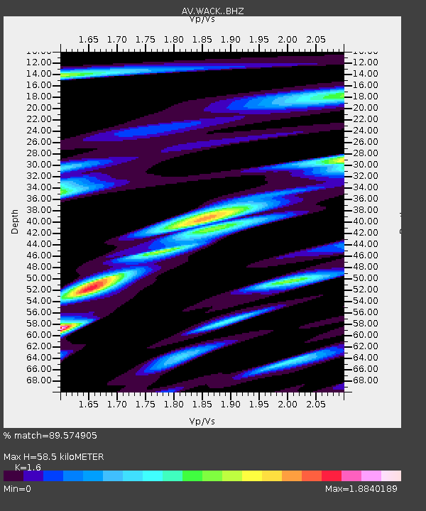
| Estimated Moho Depth: |
58.5 km |
| Estimated Crust Vp/Vs: |
1.60 |
| Assumed Crust Vp: |
6.566 km/s |
| Estimated Crust Vs: |
4.104 km/s |
| Estimated Crust Poisson's Ratio: |
0.18 |
|
| Radial Match: |
89.574905 % |
| Radial Bump: |
400 |
| Transverse Match: |
85.78213 % |
| Transverse Bump: |
400 |
| SOD ConfigId: |
13570011 |
| Insert Time: |
2019-04-28 21:25:07.795 +0000 |
| GWidth: |
2.5 |
| Max Bumps: |
400 |
| Tol: |
0.001 |
|

Signal To Noise
| Channel | StoN | STA | LTA |
| AV:WACK: :BHZ:20170926T04:32:14.859976Z | 30.091154 | 2.8374554E-6 | 9.429534E-8 |
| AV:WACK: :BHN:20170926T04:32:14.859976Z | 9.057742 | 1.1653239E-6 | 1.2865502E-7 |
| AV:WACK: :BHE:20170926T04:32:14.859976Z | 2.9816701 | 3.3875637E-7 | 1.1361296E-7 |
| Arrivals |
| Ps | 5.5 SECOND |
| PpPs | 23 SECOND |
| PsPs/PpSs | 28 SECOND |


